Photographic Print > North America > United States of America > New York > New York > Maps
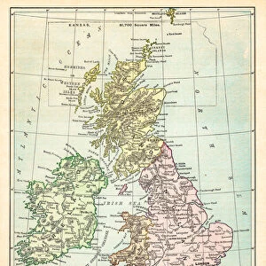
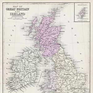
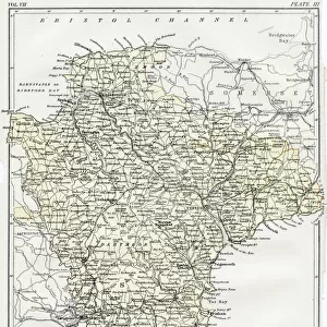
Photographic Print : British Isles map 1867


![]()
Photo Prints From Fine Art Storehouse
British Isles map 1867
Guyots Geographical Series The Earth and its inhabitants 1867 New York
Unleash your creativity and transform your space into a visual masterpiece!
THEPALMER
Media ID 14549481
© This content is subject to copyright
10"x8" Photo Print
Step back in time with our exquisite British Isles map print from The Palmer's Guyots Geographical Series, published in New York in 1867. This stunning vintage map, titled "The Earth and its inhabitants," showcases intricate detail and historical accuracy. The rich, antique tones transport you to a bygone era, making it an exceptional addition to any home or office. This Fine Art Storehouse photographic print captures the essence of cartography history, bringing a piece of the past into your present.
Photo prints are produced on Kodak professional photo paper resulting in timeless and breath-taking prints which are also ideal for framing. The colors produced are rich and vivid, with accurate blacks and pristine whites, resulting in prints that are truly timeless and magnificent. Whether you're looking to display your prints in your home, office, or gallery, our range of photographic prints are sure to impress. Dimensions refers to the size of the paper in inches.
Our Photo Prints are in a large range of sizes and are printed on Archival Quality Paper for excellent colour reproduction and longevity. They are ideal for framing (our Framed Prints use these) at a reasonable cost. Alternatives include cheaper Poster Prints and higher quality Fine Art Paper, the choice of which is largely dependant on your budget.
Estimated Product Size is 20.3cm x 25.4cm (8" x 10")
These are individually made so all sizes are approximate
Artwork printed orientated as per the preview above, with landscape (horizontal) or portrait (vertical) orientation to match the source image.
FEATURES IN THESE COLLECTIONS
> Maps and Charts
> Related Images
> North America
> United States of America
> New York
> New York
> Maps
> North America
> United States of America
> New York
> Related Images
EDITORS COMMENTS
This print showcases a remarkable piece of history, the "British Isles map 1867" from Guyots Geographical Series The Earth and its inhabitants. With its origins in New York City back in 1867, this vintage map takes us on a journey through time to explore the intricate details of the British Isles during that era. The carefully preserved print captures the essence of an age when cartography was both an art form and a scientific endeavor. Every contour line, river, and city is meticulously depicted with precision and elegance. The delicate color palette adds depth to this historical masterpiece, allowing us to immerse ourselves in the geography of yesteryears. As we gaze upon this artwork by THEPALMER from Fine Art Storehouse, we can't help but marvel at how much has changed since 1867. This map serves as a window into a world where borders were different, transportation was limited, and communication relied heavily on handwritten letters rather than instant messages. Beyond being aesthetically pleasing, this photograph holds immense educational value. It invites us to reflect upon our roots while appreciating how far we have come as societies connected by land and sea. Whether you are an avid historian or simply intrigued by antique maps, this stunning print will undoubtedly spark curiosity about Britain's past while adding timeless charm to any space it adorns.
MADE IN THE USA
Safe Shipping with 30 Day Money Back Guarantee
FREE PERSONALISATION*
We are proud to offer a range of customisation features including Personalised Captions, Color Filters and Picture Zoom Tools
SECURE PAYMENTS
We happily accept a wide range of payment options so you can pay for the things you need in the way that is most convenient for you
* Options may vary by product and licensing agreement. Zoomed Pictures can be adjusted in the Basket.