Photographic Print > North America > Related Images
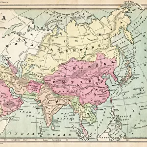
Photographic Print : North America geological map 1895


![]()
Photo Prints From Fine Art Storehouse
North America geological map 1895
Meyers Konversations-Lexikon. Ein Nachschlagewerk des allgemeinen Wissens, 5th edition 17 volumes Bibliographisches Institut - Leipzig 1895-1897
Unleash your creativity and transform your space into a visual masterpiece!
THEPALMER
Media ID 13611779
© This content is subject to copyright
Atlas Mythological Figure Canada Mexico Paper World Map
10"x8" Photo Print
Step back in time with our exquisite reproduction of the North America Geological Map from 1895, originally published in the renowned Meyers Konversations-Lexikon. This captivating fine art print, sourced from THEPALMER's collection at Fine Art Storehouse, showcases the geological compositions of North America during that era. A fascinating addition to any home or office, this print not only showcases historical cartography, but also provides a glimpse into the scientific understanding of our continent's geological makeup over a century ago. Bring history to life with this stunning and educational piece.
Photo prints are produced on Kodak professional photo paper resulting in timeless and breath-taking prints which are also ideal for framing. The colors produced are rich and vivid, with accurate blacks and pristine whites, resulting in prints that are truly timeless and magnificent. Whether you're looking to display your prints in your home, office, or gallery, our range of photographic prints are sure to impress. Dimensions refers to the size of the paper in inches.
Our Photo Prints are in a large range of sizes and are printed on Archival Quality Paper for excellent colour reproduction and longevity. They are ideal for framing (our Framed Prints use these) at a reasonable cost. Alternatives include cheaper Poster Prints and higher quality Fine Art Paper, the choice of which is largely dependant on your budget.
Estimated Product Size is 20.3cm x 25.4cm (8" x 10")
These are individually made so all sizes are approximate
Artwork printed orientated as per the preview above, with landscape (horizontal) or portrait (vertical) orientation to match the source image.
FEATURES IN THESE COLLECTIONS
> Fine Art Storehouse
> The Magical World of Illustration
> Palmer Illustrated Collection
> Fine Art Storehouse
> Map
> Historical Maps
> Fine Art Storehouse
> Map
> USA Maps
> North America
> Related Images
EDITORS COMMENTS
This print showcases a remarkable piece of history - the North America geological map from 1895. Published in the renowned Meyers Konversations-Lexikon, this map is an invaluable resource for understanding the continent's physical geography during that era. The intricate details and expert craftsmanship of this antique illustration are truly awe-inspiring. Created through engraving techniques, it beautifully depicts the vast landscapes of Canada, the United States, and Mexico. The vertical format adds a unique touch to its presentation, making it a standout piece for any collector or enthusiast. As we gaze upon this vintage map, we are transported back in time to an era when cartography was both an art form and a scientific endeavor. It serves as a testament to human curiosity and our unending quest for knowledge about our world. The presence of mythological figures on this map further adds to its allure. These ancient symbols remind us of humanity's enduring fascination with storytelling and how mythology has shaped our understanding of the natural world throughout history. Printed on high-quality paper, this print captures every minute detail with precision. Whether displayed in homes or offices, it serves as a conversation starter and invites exploration into North America's rich geological past. "The North America geological map from 1895" by THEPALMER is not just a mere image; it is an exquisite work of art that celebrates both science and aesthetics simultaneously.
MADE IN THE USA
Safe Shipping with 30 Day Money Back Guarantee
FREE PERSONALISATION*
We are proud to offer a range of customisation features including Personalised Captions, Color Filters and Picture Zoom Tools
SECURE PAYMENTS
We happily accept a wide range of payment options so you can pay for the things you need in the way that is most convenient for you
* Options may vary by product and licensing agreement. Zoomed Pictures can be adjusted in the Basket.