Photographic Print > Europe > Poland > Maps
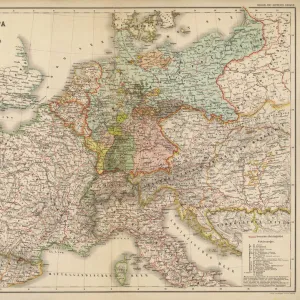
Photographic Print : Map showing the fortifications of Danzig


![]()
Photo Prints From Fine Art Finder
Map showing the fortifications of Danzig
1577233 Map showing the fortifications of Danzig; (add.info.: Map showing the fortifications of Danzig. Dated to 1687.); Universal History Archive/UIG
Media ID 38311170
© Universal History Archive/UIG / Bridgeman Images
1680s Danzig Poland Poland Polish Pole Polish
10"x8" Photo Print
Explore history with our range of Photographic Prints, including this detailed map showing the fortifications of Danzig. Perfect for adding a touch of historical charm to any space.
Photo prints are produced on Kodak professional photo paper resulting in timeless and breath-taking prints which are also ideal for framing. The colors produced are rich and vivid, with accurate blacks and pristine whites, resulting in prints that are truly timeless and magnificent. Whether you're looking to display your prints in your home, office, or gallery, our range of photographic prints are sure to impress. Dimensions refers to the size of the paper in inches.
Our Photo Prints are in a large range of sizes and are printed on Archival Quality Paper for excellent colour reproduction and longevity. They are ideal for framing (our Framed Prints use these) at a reasonable cost. Alternatives include cheaper Poster Prints and higher quality Fine Art Paper, the choice of which is largely dependant on your budget.
Estimated Product Size is 25.4cm x 20.3cm (10" x 8")
These are individually made so all sizes are approximate
Artwork printed orientated as per the preview above, with landscape (horizontal) orientation to match the source image.
FEATURES IN THESE COLLECTIONS
> Fine Art Finder
> Temp Classification
> Europe
> Poland
> Related Images
> Maps and Charts
> Early Maps
> Maps and Charts
> Related Images
EDITORS COMMENTS
This stunning print showcases a detailed map of the fortifications of Danzig, dating back to 1687. The intricate lines and markings on the map give us a glimpse into the strategic layout of this historic city in Poland.
The fortifications depicted on this map served as a vital defense system for Danzig during the 17th century, protecting the city from potential invaders and ensuring its safety and security. Each wall, tower, and gate shown on the map played a crucial role in safeguarding the inhabitants of Danzig.
As we study this piece of history, we can't help but marvel at the craftsmanship and precision that went into creating such an accurate representation of these fortifications. The attention to detail is truly remarkable, allowing us to imagine what life must have been like within these walls centuries ago.
This print serves as a reminder of the rich cultural heritage and architectural significance of Danzig. It transports us back in time to an era when fortified cities were essential for survival in Europe. We are grateful for this opportunity to explore and appreciate such historical treasures through art like this map print.
MADE IN THE USA
Safe Shipping with 30 Day Money Back Guarantee
FREE PERSONALISATION*
We are proud to offer a range of customisation features including Personalised Captions, Color Filters and Picture Zoom Tools
SECURE PAYMENTS
We happily accept a wide range of payment options so you can pay for the things you need in the way that is most convenient for you
* Options may vary by product and licensing agreement. Zoomed Pictures can be adjusted in the Basket.