Photographic Print > Africa > South Africa > Maps
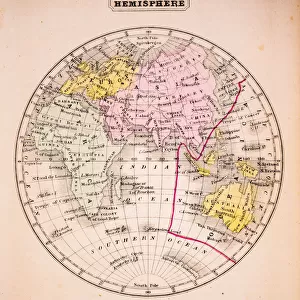
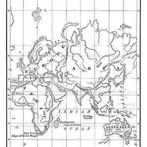
Photographic Print : Eastern Hemisphere, from a Series of World Maps published by John Tallis & Co


![]()
Photo Prints From Fine Art Finder
Eastern Hemisphere, from a Series of World Maps published by John Tallis & Co
STC190611 Eastern Hemisphere, from a Series of World Maps published by John Tallis & Co. New York & London, 1850s (engraving) by Rapkin, John (fl.1839-77); Private Collection; (add.info.: vignette illustrations by H. Warren, engraved by J. Rogers; ); The Stapleton Collection; British, out of copyright
Media ID 23224282
© The Stapleton Collection / Bridgeman Images
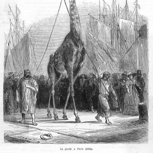
Australasia Camel Continent Continents Giraffe North Pole Polar Regions South
10"x8" Photo Print
Transport yourself back in time with Media Storehouse's exquisite collection of antique maps. This stunning Eastern Hemisphere print is taken from a Series of World Maps published by John Tallis & Co in the 1850s. The intricate engraving by Rapkin showcases the world as it was known during this era, offering a captivating glimpse into history. Perfect for adding a touch of vintage charm to your home or office, this fine art print makes a unique and thoughtful gift for map enthusiasts, historians, or anyone who appreciates the beauty of the past.
Photo prints are produced on Kodak professional photo paper resulting in timeless and breath-taking prints which are also ideal for framing. The colors produced are rich and vivid, with accurate blacks and pristine whites, resulting in prints that are truly timeless and magnificent. Whether you're looking to display your prints in your home, office, or gallery, our range of photographic prints are sure to impress. Dimensions refers to the size of the paper in inches.
Our Photo Prints are in a large range of sizes and are printed on Archival Quality Paper for excellent colour reproduction and longevity. They are ideal for framing (our Framed Prints use these) at a reasonable cost. Alternatives include cheaper Poster Prints and higher quality Fine Art Paper, the choice of which is largely dependant on your budget.
Estimated Product Size is 25.4cm x 20.3cm (10" x 8")
These are individually made so all sizes are approximate
Artwork printed orientated as per the preview above, with landscape (horizontal) or portrait (vertical) orientation to match the source image.
FEATURES IN THESE COLLECTIONS
> Fine Art Finder
> Artists
> Henri J.F. (1844-1910) Rousseau
> Fine Art Finder
> Artists
> John Rapkin
> Fine Art Finder
> Maps (celestial & Terrestrial)
> Africa
> South Africa
> Maps
> Africa
> South Africa
> Related Images
> Animals
> Farm
> Related Images
> Animals
> Mammals
> Bovidae
> Giraffe
> Animals
> Mammals
> Giraffidae
> Giraffe
> Arts
> Artists
> R
> John Rapkin
> Arts
> Artists
> R
> John Rogers
> Arts
> Artists
> T
> John Tallis
EDITORS COMMENTS
This print showcases the "Eastern Hemisphere" from a renowned series of world maps published by John Tallis & Co in the 1850s. The intricate engraving, created by John Rapkin and featuring vignette illustrations by H. Warren, takes us on a visual journey through various continents and regions. The map reveals an array of fascinating elements that make it truly mesmerizing. From soldiers marching across vast landscapes to native inhabitants engaging with exotic wildlife, this artwork encapsulates the diversity and richness of our planet's eastern hemisphere. As we explore this masterpiece, our eyes are drawn to the majestic giraffe gracefully roaming amidst Africa's lush savannahs. Further north, near the polar regions, we spot horses galloping freely alongside camels traversing arid terrains—a striking contrast between two distinct modes of transportation. Europe stands out with its historical landmarks and bustling cities depicted in remarkable detail. Meanwhile, Asia captivates us with its vibrant cultures and ancient traditions represented through indigenous people engaged in their daily lives. This print not only serves as a stunning piece of art but also offers a glimpse into our world's past—an invaluable resource for historians and enthusiasts alike. It reminds us of how interconnected our global community has always been while celebrating the beauty found within each continent.
MADE IN THE USA
Safe Shipping with 30 Day Money Back Guarantee
FREE PERSONALISATION*
We are proud to offer a range of customisation features including Personalised Captions, Color Filters and Picture Zoom Tools
SECURE PAYMENTS
We happily accept a wide range of payment options so you can pay for the things you need in the way that is most convenient for you
* Options may vary by product and licensing agreement. Zoomed Pictures can be adjusted in the Basket.