Photographic Print > Arts > Artists > B > Joan Blaeu
Photographic Print : Ms 1288 Chart of Sumatra, 1653 (pen, ink & wash on paper)
")

![]()
Photo Prints From Fine Art Finder
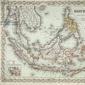
Ms 1288 Chart of Sumatra, 1653 (pen, ink & wash on paper)
BIF391162 Ms 1288 Chart of Sumatra, 1653 (pen, ink & wash on paper) by Blaeu, Joan (1596-1673); Bibliotheque de l Institut de France, Paris, France; Dutch, out of copyright
Media ID 23475278
© Bridgeman Images
Indian Ocean Indonesia Java Mapping South East Asia
10"x8" Photo Print
Discover the captivating history of Sumatra with our exquisite print from Media Storehouse. This rare and intriguing map, titled "Ms 1283 Chart of Sumatra, 1653," is an exceptional work of art by renowned Dutch cartographer Joan Blaeu. Meticulously hand-drawn in pen, ink, and wash on paper, this detailed chart showcases the complex geography of Sumatra during the 17th century. Add an air of sophistication and historical depth to your home or office with this beautiful fine art print, proudly sourced from Bridgeman Images and the Bibliotheque de l'Institut de France in Paris. Out of copyright and ready to inspire your imagination.
Photo prints are produced on Kodak professional photo paper resulting in timeless and breath-taking prints which are also ideal for framing. The colors produced are rich and vivid, with accurate blacks and pristine whites, resulting in prints that are truly timeless and magnificent. Whether you're looking to display your prints in your home, office, or gallery, our range of photographic prints are sure to impress. Dimensions refers to the size of the paper in inches.
Our Photo Prints are in a large range of sizes and are printed on Archival Quality Paper for excellent colour reproduction and longevity. They are ideal for framing (our Framed Prints use these) at a reasonable cost. Alternatives include cheaper Poster Prints and higher quality Fine Art Paper, the choice of which is largely dependant on your budget.
Estimated Product Size is 20.3cm x 25.4cm (8" x 10")
These are individually made so all sizes are approximate
Artwork printed orientated as per the preview above, with portrait (vertical) orientation to match the source image.
FEATURES IN THESE COLLECTIONS
> Fine Art Finder
> Artists
> French School
> Fine Art Finder
> Artists
> Joan Blaeu
> Fine Art Finder
> Maps (celestial & Terrestrial)
> Arts
> Artists
> B
> Joan Blaeu
> Arts
> Artists
> O
> Oceanic Oceanic
> Asia
> Indonesia
> Related Images
> Europe
> France
> Paris
> Maps
> Maps and Charts
> Related Images
EDITORS COMMENTS
This print showcases the intricate beauty of "Ms 1288 Chart of Sumatra, 1653" by Joan Blaeu. Created with pen, ink, and wash on paper, this stunning piece of cartography transports us back to a time when exploration and discovery were at their peak. The chart depicts the Indonesian island of Sumatra in meticulous detail, capturing its lush landscapes and coastal features with remarkable precision. As we gaze upon this artwork, we are transported to a world where maps were not just tools for navigation but also works of art that captured the imagination. Blaeu's expertise as a Dutch cartographer shines through in every stroke of his pen. The attention to detail is awe-inspiring; from the delicate lines that trace the contours of Java Island to the intricate patterns denoting rivers and mountains. It is evident that this map was crafted with both scientific accuracy and artistic finesse. As we study this masterpiece further, our eyes are drawn towards the Indian Ocean surrounding Sumatra. We can almost feel the vastness and power emanating from those swirling waves meticulously rendered in ink. This chart serves as a testament to humanity's insatiable thirst for knowledge about distant lands. Displayed proudly within Bibliotheque de l'Institut de France in Paris, France, this print captures an important chapter in history when explorers sought new horizons across South East Asia. It reminds us how far we have come while igniting our curiosity for what lies beyond our known world
MADE IN THE USA
Safe Shipping with 30 Day Money Back Guarantee
FREE PERSONALISATION*
We are proud to offer a range of customisation features including Personalised Captions, Color Filters and Picture Zoom Tools
SECURE PAYMENTS
We happily accept a wide range of payment options so you can pay for the things you need in the way that is most convenient for you
* Options may vary by product and licensing agreement. Zoomed Pictures can be adjusted in the Basket.