Photographic Print > Europe > France > Maps
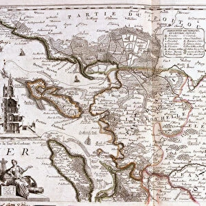
Photographic Print : Map of North America, 1708 (etching, 1717)
")

![]()
Photo Prints From Fine Art Finder
Map of North America, 1708 (etching, 1717)
LRI4711129 Map of North America, 1708 (etching, 1717) by Nolin, Jean-Baptiste (c.1657-1708); Private Collection; (add.info.: Map of North America, 1708 - Engraving from the atlas le theatre du monde, 1717, by Jean Baptiste Nolin (1686-1762) - Map of North America, 1708 - - From " Le Theatre du Monde" 1717 by Jean-Baptiste Nolin); Luisa Ricciarini; French, out of copyright
Media ID 23717042
© Luisa Ricciarini / Bridgeman Images
Atlas Book Central America Form North Pole Semicircle Geographical Map Half Circle
10"x8" Photo Print
Discover the historical wonders of cartography with our exquisite reproduction of Jean-Baptiste Nolin's Map of North America from 1708. This intricately detailed etching, originally created over 300 years ago, showcases the vast expanse of North America as it was known during that time. The map is brought to life by Luisa Ricciarini's masterful photography, capturing every line and detail of the original piece from Fine Art Finder's private collection. Add an air of history and sophistication to your home or office with this stunning, museum-quality photographic print.
Photo prints are produced on Kodak professional photo paper resulting in timeless and breath-taking prints which are also ideal for framing. The colors produced are rich and vivid, with accurate blacks and pristine whites, resulting in prints that are truly timeless and magnificent. Whether you're looking to display your prints in your home, office, or gallery, our range of photographic prints are sure to impress. Dimensions refers to the size of the paper in inches.
Our Photo Prints are in a large range of sizes and are printed on Archival Quality Paper for excellent colour reproduction and longevity. They are ideal for framing (our Framed Prints use these) at a reasonable cost. Alternatives include cheaper Poster Prints and higher quality Fine Art Paper, the choice of which is largely dependant on your budget.
Estimated Product Size is 25.4cm x 20.3cm (10" x 8")
These are individually made so all sizes are approximate
Artwork printed orientated as per the preview above, with landscape (horizontal) or portrait (vertical) orientation to match the source image.
FEATURES IN THESE COLLECTIONS
> Fine Art Finder
> Artists
> Franz Hogenberg
> Fine Art Finder
> Artists
> Jean-Baptiste Nolin
> Maps and Charts
> Related Images
EDITORS COMMENTS
This print showcases a remarkable piece of cartographic history - the "Map of North America, 1708". Created by Jean-Baptiste Nolin in 1717, this etching is a part of his renowned atlas "Le Theatre du Monde". The map itself provides an intriguing glimpse into the geographical understanding and exploration of North America during the early 18th century. With intricate details and precise craftsmanship, Nolin captures the vastness and diversity of this continent. From the frozen landscapes near the north pole to the vibrant lands of Central America, every corner is meticulously depicted on this map. The semicircular shape adds a unique aesthetic touch, making it visually striking. As we delve deeper into its intricacies, we can appreciate how this historical artifact serves as both an informative tool and a work of art. Its inclusion in private collections speaks to its significance among collectors and enthusiasts alike. Luisa Ricciarini's expertly captured photograph allows us to admire not only Nolin's masterpiece but also her own artistic talent. Through her lens, she brings out every detail with precision and clarity. In sharing this image with us through Fine Art Finder, Luisa Ricciarini invites us to explore our fascination with history, geography, and art all at once. It reminds us that even centuries-old maps can continue to captivate our imagination today.
MADE IN THE USA
Safe Shipping with 30 Day Money Back Guarantee
FREE PERSONALISATION*
We are proud to offer a range of customisation features including Personalised Captions, Color Filters and Picture Zoom Tools
SECURE PAYMENTS
We happily accept a wide range of payment options so you can pay for the things you need in the way that is most convenient for you
* Options may vary by product and licensing agreement. Zoomed Pictures can be adjusted in the Basket.