Photo Mug > Animals > Fishes > G > Grouper
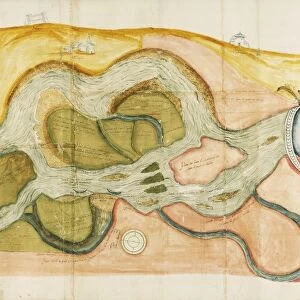
Photo Mug : Map of city of Ferrara, by Andrea Bolzoni, drawing


![]()
Home Decor From Universal Images Group (UIG)
Map of city of Ferrara, by Andrea Bolzoni, drawing
Cartography, Italy, 18th century. Map of the city of Ferrara, drawing by Andrea Bolzoni
Universal Images Group (UIG) manages distribution for many leading specialist agencies worldwide
Media ID 9572915
© DEA PICTURE LIBRARY
18th Century Drawing Ferrara Fortified Walls Street
Large Photo Mug (15 oz)
Bring a piece of history to your morning routine with our Media Storehouse Photo Mug featuring a stunning 18th century map of Ferrara by Andrea Bolzoni. This exquisite map, sourced from Universal Images Group, showcases the rich cartography of Italy with intricate details and vibrant colors. Each mug holds your favorite beverage while allowing you to enjoy the beauty of this historical masterpiece. Perfect for history enthusiasts, travelers, or anyone who appreciates the art of cartography. Embrace the past, one sip at a time.
Elevate your coffee or tea experience with our premium white ceramic mug. Its wide, comfortable handle makes drinking easy, and you can rely on it to be both microwave and dishwasher safe. Sold in single units, preview may show both sides of the same mug so you can see how the picture wraps around.
Elevate your coffee or tea experience with our premium white ceramic mug. Its wide, comfortable handle makes drinking easy, and you can rely on it to be both microwave and dishwasher safe. Sold in single units, preview may show both sides of the same mug so you can see how the picture wraps around.
These are individually made so all sizes are approximate
FEATURES IN THESE COLLECTIONS
> Animals
> Fishes
> G
> Grouper
> Architecture
> Country
> Italy
> Related Images
> Architecture
> Drawings
> Arts
> Portraits
> Pop art gallery
> Street art portraits
> Europe
> Italy
> Emilia-Romagna
> Ferrara
> Europe
> Italy
> Heritage Sites
> Ferrara, City of the Renaissance
> Maps and Charts
> Italy
> Maps and Charts
> Related Images
EDITORS COMMENTS
This print showcases a remarkable piece of cartography from the 18th century, specifically a map of the city of Ferrara in Italy. Created by the talented artist Andrea Bolzoni, this drawing provides an intricate and detailed depiction of Ferrara's streets and architecture during that era. The image is presented in full length, allowing viewers to immerse themselves in the rich history and physical geography of this enchanting Italian city. The studio shot captures every aspect of Bolzoni's masterpiece, emphasizing its horizontal layout and showcasing its impressive scale. With no people present in the image, all attention is drawn to the meticulously illustrated buildings, fortified walls, and other architectural elements that define Ferrara's past. This artful representation not only serves as a valuable historical document but also highlights Bolzoni's exceptional skill as an illustrator. The precision with which he has captured each street corner and building exterior is truly awe-inspiring. As we gaze upon this stunning artwork, we are transported back in time to witness firsthand how Ferrara appeared centuries ago. It offers us a glimpse into a world where fortified walls protected its inhabitants while beautiful structures adorned its streets. This print allows us to appreciate both the craftsmanship involved in creating such maps as well as the beauty inherent within historic cities like Ferrara.
MADE IN THE USA
Safe Shipping with 30 Day Money Back Guarantee
FREE PERSONALISATION*
We are proud to offer a range of customisation features including Personalised Captions, Color Filters and Picture Zoom Tools
SECURE PAYMENTS
We happily accept a wide range of payment options so you can pay for the things you need in the way that is most convenient for you
* Options may vary by product and licensing agreement. Zoomed Pictures can be adjusted in the Basket.