Photo Mug > Asia > Palestine > Maps
Photo Mug : Map Asia Palestine Bible Maps 1st Century Ad


![]()
Home Decor from Mary Evans Picture Library
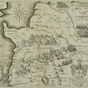
Map Asia Palestine Bible Maps 1st Century Ad
map, asia, palestine, bible, maps, 1st, century, ad, new, testament, times, religion, coast, dead, sea, history, historical, 10114185
Mary Evans Picture Library makes available wonderful images created for people to enjoy over the centuries
Media ID 32217166
© Mary Evans Picture Library 2015
Dead Maps Palestine Testament Times
Large Photo Mug (15 oz)
Discover the rich history and religious significance of the ancient lands of Asia and Palestine with our Media Storehouse Photo Mugs. Featuring a captivating map from Mary Evans Prints Online, this mug showcases intricate details of the 1st Century AD Bible Maps of Asia and Palestine, including the coastlines of the Mediterranean Sea, the Dead Sea, and the Holy Land. Ideal for history buffs, students of religion, or anyone with a deep appreciation for the times of the New Testament, this mug makes a thoughtful and unique gift. Each mug is expertly printed with high-quality, vibrant colors to bring the map to life, ensuring your morning coffee or tea becomes a daily reminder of the fascinating history and culture of the region.
Elevate your coffee or tea experience with our premium white ceramic mug. Its wide, comfortable handle makes drinking easy, and you can rely on it to be both microwave and dishwasher safe. Sold in single units, preview may show both sides of the same mug so you can see how the picture wraps around.
Elevate your coffee or tea experience with our premium white ceramic mug. Its wide, comfortable handle makes drinking easy, and you can rely on it to be both microwave and dishwasher safe. Sold in single units, preview may show both sides of the same mug so you can see how the picture wraps around.
These are individually made so all sizes are approximate
FEATURES IN THESE COLLECTIONS
> Mary Evans Prints Online
> New Images July 2023
> Asia
> Palestine
> Related Images
> Asia
> Related Images
> Maps and Charts
> Early Maps
> Maps and Charts
> Related Images
EDITORS COMMENTS
This print of Map Asia Palestine Bible Maps from the 1st Century AD offers a glimpse into the historical and religious significance of this region during New Testament times. The intricate details on the map showcase key locations such as the coast of the Dead Sea, providing a visual representation of biblical events and stories that have shaped our understanding of faith and history.
As we study this map, we are transported back in time to an era filled with rich cultural heritage and spiritual significance. The intricate lines and symbols on the map offer a window into the past, allowing us to trace the footsteps of ancient civilizations and explore their connections to modern-day beliefs.
The inclusion of Palestine on this map serves as a reminder of its importance in biblical narratives, highlighting its role as a sacred land for many religions. By examining this piece closely, we can gain valuable insights into how geography has influenced religious practices and traditions throughout history.
Overall, this print is not just a visual representation but also a gateway to deeper exploration and contemplation about the intersection between religion, history, and culture in one of the most revered regions in human civilization.
MADE IN THE USA
Safe Shipping with 30 Day Money Back Guarantee
FREE PERSONALISATION*
We are proud to offer a range of customisation features including Personalised Captions, Color Filters and Picture Zoom Tools
SECURE PAYMENTS
We happily accept a wide range of payment options so you can pay for the things you need in the way that is most convenient for you
* Options may vary by product and licensing agreement. Zoomed Pictures can be adjusted in the Cart.