Photo Mug > Europe > Poland > Maps
Photo Mug : Map / Europe / Poland 1772


![]()
Home Decor from Mary Evans Picture Library
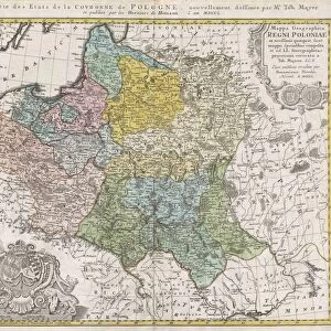
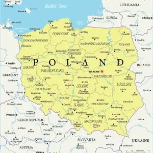
Map / Europe / Poland 1772
A German map of Poland and its neighbours in the late 18th century
Mary Evans Picture Library makes available wonderful images created for people to enjoy over the centuries
Media ID 594544
© Mary Evans Picture Library 2015 - https://copyrighthub.org/s0/hub1/creation/maryevans/MaryEvansPictureID/10046847
Large Photo Mug (15 oz)
Introducing our latest addition to the Media Storehouse Photo Mug collection: a unique and captivating way to start your day. This mug showcases an intriguing historical map of Europe, specifically Poland in 1772, as depicted in the "Map / Europe / Poland 1772" print from Mary Evans Picture Library. With vivid colors and intricate details, this map transports you back in time, making your morning coffee or tea break an educational and visually stimulating experience. Add a personal touch by gifting this mug to a history enthusiast or as a thoughtful addition to your own collection. Embrace the richness of the past with every sip.
Elevate your coffee or tea experience with our premium white ceramic mug. Its wide, comfortable handle makes drinking easy, and you can rely on it to be both microwave and dishwasher safe. Sold in single units, preview may show both sides of the same mug so you can see how the picture wraps around.
Elevate your coffee or tea experience with our premium white ceramic mug. Its wide, comfortable handle makes drinking easy, and you can rely on it to be both microwave and dishwasher safe. Sold in single units, preview may show both sides of the same mug so you can see how the picture wraps around.
These are individually made so all sizes are approximate
FEATURES IN THESE COLLECTIONS
> Mary Evans Prints Online
> Maps
> Europe
> Germany
> Related Images
> Europe
> Poland
> Related Images
> Europe
> Related Images
> Maps and Charts
> Early Maps
EDITORS COMMENTS
This fascinating historical print from Mary Evans Picture Library showcases a German map of Poland and its neighboring countries in the late 18th century. The year is 1772, a time when Europe was undergoing significant political and territorial changes. This meticulously detailed map offers a glimpse into the complex geopolitical landscape of that era, with intricate borders and place names that reflect the shifting alliances and power struggles of the time.
As we study this map, we can see how Poland was situated among its neighbors, including Prussia, Austria, Russia, and others. Each region is clearly delineated with precision and accuracy, providing valuable insight into the boundaries and territories of these nations during this period.
The rich history captured in this print allows us to travel back in time and explore Europe as it existed over two centuries ago. It serves as a reminder of the ever-changing nature of politics and geography, highlighting how borders have shifted over time due to wars, treaties, and other factors.
For history enthusiasts or anyone interested in cartography, this German map of Poland from 1772 is sure to spark curiosity and fascination. It stands as a testament to the enduring importance of maps in understanding our past and navigating our present world.
MADE IN THE USA
Safe Shipping with 30 Day Money Back Guarantee
FREE PERSONALISATION*
We are proud to offer a range of customisation features including Personalised Captions, Color Filters and Picture Zoom Tools
SECURE PAYMENTS
We happily accept a wide range of payment options so you can pay for the things you need in the way that is most convenient for you
* Options may vary by product and licensing agreement. Zoomed Pictures can be adjusted in the Cart.