Photo Mug > Europe > Related Images
Photo Mug : Map / Europe C1840


![]()
Home Decor from Mary Evans Picture Library
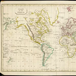
Map / Europe C1840
Map of Europe Date: circa 1840
Mary Evans Picture Library makes available wonderful images created for people to enjoy over the centuries
Media ID 7122001
© Mary Evans Picture Library 2015 - https://copyrighthub.org/s0/hub1/creation/maryevans/MaryEvansPictureID/10114203
Large Photo Mug (15 oz)
"Bring history to your morning routine with our Media Storehouse Photo Mugs. Featuring an exquisite vintage map of Europe from circa 1840, sourced from Mary Evans Prints Online, these mugs are not just functional but also a delightful way to start your day. Each mug showcases high-quality print of the Map / Europe C1840, ensuring that every sip takes you on a journey through time. Perfect for the history enthusiast or anyone who appreciates the beauty of old maps, these mugs make for unique and thoughtful gifts. Embrace the past, one cup at a time."
Elevate your coffee or tea experience with our premium white ceramic mug. Its wide, comfortable handle makes drinking easy, and you can rely on it to be both microwave and dishwasher safe. Sold in single units, preview may show both sides of the same mug so you can see how the picture wraps around.
Elevate your coffee or tea experience with our premium white ceramic mug. Its wide, comfortable handle makes drinking easy, and you can rely on it to be both microwave and dishwasher safe. Sold in single units, preview may show both sides of the same mug so you can see how the picture wraps around.
These are individually made so all sizes are approximate
FEATURES IN THESE COLLECTIONS
> Europe
> Related Images
> Maps and Charts
> Related Images
EDITORS COMMENTS
1. Title: "Exploring the Past: A Glimpse into Europe's Historical Landscapes through a 1840 Map" This antique map print, dated circa 1840, offers a fascinating glimpse into Europe's historical landscapes as they appeared over 170 years ago. The intricate details of this map, sourced from Mary Evans Prints Online, provide an invaluable record of the geographical knowledge and cartographic skills of the time. The map, titled "Europe," is adorned with borders depicting various European coats of arms, adding a touch of elegance and historical authenticity. The intricate cartography reveals the political divisions of Europe during the 19th century, with borders clearly delineating the territories of various European powers. The map also features annotations, including the names of major cities, rivers, and mountains, providing a wealth of information for those interested in European history and geography. The inclusion of detailed coastlines and topographical features further enhances the map's value as a historical document. As we explore this map, we are transported back in time to an era of exploration, discovery, and the expansion of European empires. The map serves as a testament to the advances in cartography and the growing European interest in mapping and understanding their world. This map print is not only an essential addition to any history or geography enthusiast's collection but also a beautiful piece of art that adds character and charm to any room. Its intricate details and historical significance make it a captivating conversation starter and a reminder of Europe's rich history. In conclusion, this 1840 map of Europe is more than just a geographical representation; it is a window into the past, offering a unique perspective on Europe's historical landscapes and the knowledge and skills of the cartographers of the time.
MADE IN THE USA
Safe Shipping with 30 Day Money Back Guarantee
FREE PERSONALISATION*
We are proud to offer a range of customisation features including Personalised Captions, Color Filters and Picture Zoom Tools
SECURE PAYMENTS
We happily accept a wide range of payment options so you can pay for the things you need in the way that is most convenient for you
* Options may vary by product and licensing agreement. Zoomed Pictures can be adjusted in the Cart.