Photo Mug > Maps and Charts > World
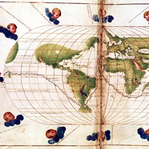
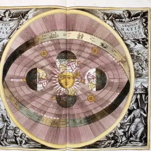
Photo Mug : Orbis terrarum nova et accuratissima tabula, ca 1690. Artist: Visscher, Nicolaes (1618-1679)
")
")
![]()
Home Decor From Heritage Images
Orbis terrarum nova et accuratissima tabula, ca 1690. Artist: Visscher, Nicolaes (1618-1679)
Orbis terrarum nova et accuratissima tabula, ca 1690. Private Collection
Heritage Images features heritage image collections
Media ID 15029898
© Fine Art Images
Cartography Map Of The World Maps Visscher World Map
Large Photo Mug (15 oz)
Add a touch of history to your morning routine with our Media Storehouse Photo Mugs, featuring the intricately detailed and captivating Orbis Terrarum Nova et Accuratissima Tabula map. This stunning 1690 map, created by renowned Dutch cartographer Nicolaes Visscher, showcases the world as it was known at the time with meticulous accuracy. Each mug holds your favorite beverage while providing a daily reminder of the wonders of exploration and the richness of our world's history. Embrace the past, one sip at a time.
Elevate your coffee or tea experience with our premium white ceramic mug. Its wide, comfortable handle makes drinking easy, and you can rely on it to be both microwave and dishwasher safe. Sold in single units, preview may show both sides of the same mug so you can see how the picture wraps around.
Elevate your coffee or tea experience with our premium white ceramic mug. Its wide, comfortable handle makes drinking easy, and you can rely on it to be both microwave and dishwasher safe. Sold in single units, preview may show both sides of the same mug so you can see how the picture wraps around.
These are individually made so all sizes are approximate
FEATURES IN THESE COLLECTIONS
> Heritage Images
> Maps Charts & Plans
> Maps and Charts
> Related Images
> Maps and Charts
> World
EDITORS COMMENTS
This print showcases the exquisite masterpiece titled "Orbis terrarum nova et accuratissima tabula" by renowned artist Nicolaes Visscher. Created around 1690, this map is a true testament to Visscher's exceptional talent in cartography and fine art. The image captures the intricate details of this world map, offering viewers a glimpse into the historical significance of Holland's rich cartographic tradition. The careful etching and precise graphic arts techniques employed by Visscher are evident in every corner of this remarkable piece. As we explore the vastness of this meticulously crafted map, we are transported back in time to an era when exploration and discovery were at their peak. Each continent, ocean, and landmass is depicted with utmost accuracy, providing us with a comprehensive understanding of our planet as it was perceived during that period. This particular print belongs to a private collection, serving as a reminder of how valuable such artistic treasures truly are. It serves as an invitation for all history enthusiasts and admirers of fine art to delve into the fascinating world of maps from centuries past. With its timeless beauty and profound historical significance, "Orbis terrarum nova et accuratissima tabula" continues to captivate audiences today just as it did when first created by the talented hands of Nicolaes Visscher over three centuries ago.
MADE IN THE USA
Safe Shipping with 30 Day Money Back Guarantee
FREE PERSONALISATION*
We are proud to offer a range of customisation features including Personalised Captions, Color Filters and Picture Zoom Tools
SECURE PAYMENTS
We happily accept a wide range of payment options so you can pay for the things you need in the way that is most convenient for you
* Options may vary by product and licensing agreement. Zoomed Pictures can be adjusted in the Basket.