Photo Mug > Europe > United Kingdom > Scotland > Edinburgh > Edinburgh
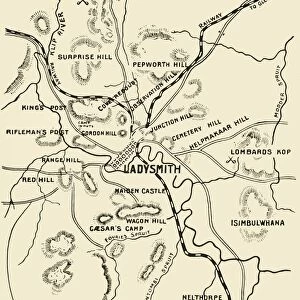
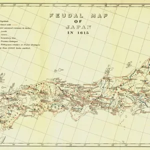
Photo Mug : Map of Northern Natal. Scale 15 Statute Miles to the Inch, 1900. Creator: Unknown


![]()
Home Decor From Heritage Images
Map of Northern Natal. Scale 15 Statute Miles to the Inch, 1900. Creator: Unknown
Map of Northern Natal. Scale 15 Statute Miles to the Inch, 1900. From " South Africa and the Transvaal War, Vol. II", by Louis Creswicke. [T. C. & E. C. Jack, Edinburgh, 1900]
Heritage Images features heritage image collections
Media ID 19780697
© The Print Collector/Heritage Images
Cartography Creswicke Jack Louis Louis Creswicke Map Making Mapmaking Natal South Africa South Africa And The Transvaal War Tc And Ec Tc And Ec Jack
Large Photo Mug (15 oz)
Step back in time with our vintage Photo Mug featuring a captivating Map of Northern Natal from 1900. This intricately detailed map, sourced from the pages of "South Africa and the Transvaal War, Vol. II," showcases the region's topography with a scale of 15 statute miles to the inch. The unknown creator's heritage image comes to life on this mug, making each sip an adventure through history. Embrace the past and enjoy your favorite beverage in style with this unique and collectible Photo Mug from Media Storehouse.
Elevate your coffee or tea experience with our premium white ceramic mug. Its wide, comfortable handle makes drinking easy, and you can rely on it to be both microwave and dishwasher safe. Sold in single units, preview may show both sides of the same mug so you can see how the picture wraps around.
Elevate your coffee or tea experience with our premium white ceramic mug. Its wide, comfortable handle makes drinking easy, and you can rely on it to be both microwave and dishwasher safe. Sold in single units, preview may show both sides of the same mug so you can see how the picture wraps around.
These are individually made so all sizes are approximate
FEATURES IN THESE COLLECTIONS
> Africa
> South Africa
> Maps
> Africa
> South Africa
> Related Images
> Arts
> Literature
> Illustration
> Arts
> Literature
> Europe
> United Kingdom
> Scotland
> Edinburgh
> Edinburgh
> Europe
> United Kingdom
> Scotland
> Lothian
> Edinburgh
> Maps and Charts
> Related Images
EDITORS COMMENTS
This print showcases a historical gem, the "Map of Northern Natal". Created in 1900 by an unknown cartographer, this map is a testament to the artistry and precision of early 20th-century mapmaking. With a scale of 15 statute miles to the inch, it provides intricate details of the region's geography. Taken from Louis Creswicke's renowned book "South Africa and the Transvaal War" this print offers us a glimpse into both African literature and history. The map's inclusion in Creswicke's work highlights its significance as an essential tool for understanding South Africa during that time period. The image transports us back to the late 19th century, when exploration and discovery were at their peak. It serves as a reminder of how far we have come in our understanding of continents, countries, and their locations. This piece also sheds light on the importance of cartography as a means to document and navigate vast territories. Preserved by The Print Collector, this photograph allows us to appreciate not only its aesthetic value but also its cultural significance. As we gaze upon this beautifully illustrated map with its intricate details and elegant typography, we are reminded of the rich heritage that lies within such artifacts. Whether you are an avid collector or simply intrigued by history, this remarkable print is sure to captivate your imagination while offering valuable insights into South Africa's past.
MADE IN THE USA
Safe Shipping with 30 Day Money Back Guarantee
FREE PERSONALISATION*
We are proud to offer a range of customisation features including Personalised Captions, Color Filters and Picture Zoom Tools
SECURE PAYMENTS
We happily accept a wide range of payment options so you can pay for the things you need in the way that is most convenient for you
* Options may vary by product and licensing agreement. Zoomed Pictures can be adjusted in the Basket.