Photo Mug > Maps and Charts > Americas
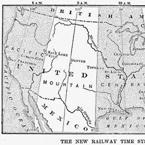
Photo Mug : U. S. A. TIME ZONES MAP, 1883. An 1883 map of the United States showing the standard


![]()
Home Decor from Granger
U. S. A. TIME ZONES MAP, 1883. An 1883 map of the United States showing the standard
U.S.A. TIME ZONES MAP, 1883.
An 1883 map of the United States showing the standard time zones adopted that year
Granger holds millions of images spanning more than 25,000 years of world history, from before the Stone Age to the dawn of the Space Age
Media ID 12320959
1883 Central Eastern Measurement Mountain Pacific Standard Time United States Zone
Large Photo Mug (15 oz)
Step back in time with our unique Photo Mug from Media Storehouse. Featuring an intriguing 1883 U.S.A. Time Zones Map, this mug showcases the historical standard time zones adopted in the United States. Decorated with an authentic 1883 map obtained from Granger Art on Demand, each sip from this mug brings a piece of history to your daily routine. Perfect for history enthusiasts, collectors, or anyone who appreciates the beauty of vintage maps, this Photo Mug is sure to impress.
Elevate your coffee or tea experience with our premium white ceramic mug. Its wide, comfortable handle makes drinking easy, and you can rely on it to be both microwave and dishwasher safe. Sold in single units, preview may show both sides of the same mug so you can see how the picture wraps around.
Elevate your coffee or tea experience with our premium white ceramic mug. Its wide, comfortable handle makes drinking easy, and you can rely on it to be both microwave and dishwasher safe. Sold in single units, preview may show both sides of the same mug so you can see how the picture wraps around.
These are individually made so all sizes are approximate
FEATURES IN THESE COLLECTIONS
> Granger Art on Demand
> Maps
> Maps and Charts
> Related Images
EDITORS COMMENTS
This print transports us back to the year 1883, showcasing an intricately detailed map of the United States. The focus of this historical piece is the standard time zones that were adopted during that significant year. As we delve into this snapshot from the past, we are reminded of how crucial accurate time measurement became in a rapidly developing nation. The map highlights four main time zones: Eastern, Central, Mountain, and Pacific. Each zone is meticulously outlined with precision and clarity, allowing viewers to grasp the vastness of America's territory and its diverse regions. This visual representation serves as a reminder of the immense challenges faced by early travelers and communication systems in coordinating schedules across such expansive distances. As we examine this vintage artifact further, it becomes evident that this map played a pivotal role in unifying a nation on common temporal ground. It symbolizes progress and innovation as America embraced standardized timekeeping for enhanced efficiency in transportation networks, commerce, and daily life. Granger Art on Demand has impeccably captured this timeless piece from history with their high-quality reproduction. Whether you're an avid historian or simply intrigued by our collective past, this U. S. A Time Zones Map offers a fascinating glimpse into an era when measuring time was not just about minutes ticking away but also about uniting a nation under one synchronized clock face.
MADE IN THE USA
Safe Shipping with 30 Day Money Back Guarantee
FREE PERSONALISATION*
We are proud to offer a range of customisation features including Personalised Captions, Color Filters and Picture Zoom Tools
SECURE PAYMENTS
We happily accept a wide range of payment options so you can pay for the things you need in the way that is most convenient for you
* Options may vary by product and licensing agreement. Zoomed Pictures can be adjusted in the Cart.