Photo Mug > North America > United States of America > New York > New York > Maps
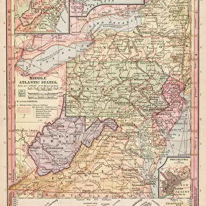
Photo Mug : Map Middle Atlantic States 1899


![]()
Home Decor From Fine Art Storehouse
Map Middle Atlantic States 1899
Maurys Geographical Series Manual of Geography - New York 1899
Unleash your creativity and transform your space into a visual masterpiece!
THEPALMER
Media ID 20114737
© A 2014 Roberto Adrian Photography
Large Photo Mug (15 oz)
Add a touch of history to your morning routine with our Media Storehouse Photo Mug featuring the vintage Map of Middle Atlantic States from 1899 by THEPALMER, originally published in Maurys Geographical Series Manual of Geography from New York. This high-quality mug showcases intricate details of the map, transporting you back in time with every sip. Perfect for history enthusiasts, geography buffs, or anyone who appreciates the beauty of old maps. Embrace the past, one mug at a time.
Elevate your coffee or tea experience with our premium white ceramic mug. Its wide, comfortable handle makes drinking easy, and you can rely on it to be both microwave and dishwasher safe. Sold in single units, preview may show both sides of the same mug so you can see how the picture wraps around.
Elevate your coffee or tea experience with our premium white ceramic mug. Its wide, comfortable handle makes drinking easy, and you can rely on it to be both microwave and dishwasher safe. Sold in single units, preview may show both sides of the same mug so you can see how the picture wraps around.
These are individually made so all sizes are approximate
FEATURES IN THESE COLLECTIONS
> Maps and Charts
> Related Images
> North America
> United States of America
> New York
> New York
> Maps
> North America
> United States of America
> New York
> Related Images
EDITORS COMMENTS
This print titled "Map Middle Atlantic States 1899" takes us on a journey back in time to the late 19th century. A part of Maurys Geographical Series Manual of Geography, this vintage map showcases the intricate details and artistry that were once employed in cartography. The map focuses specifically on the Middle Atlantic States, offering a glimpse into their geographical features, cities, towns, and transportation routes as they stood over a century ago. The delicate lines and vibrant colors used by THEPALMER bring life to this historical document, making it an exquisite piece for any history enthusiast or lover of fine art. As we study this map closely, we can't help but marvel at how much has changed since its creation. It serves as a reminder of the rapid development and urbanization that have transformed these states throughout the years. Yet despite these changes, there is also comfort in knowing that some landmarks depicted here still stand today - connecting us to our past while guiding us towards our future. Whether displayed in a classroom or adorning the walls of a home library or office space, this print invites viewers to explore history through both an artistic lens and geographic perspective. Its timeless beauty captures not only our imagination but also sparks curiosity about how these states have evolved over time.
MADE IN THE USA
Safe Shipping with 30 Day Money Back Guarantee
FREE PERSONALISATION*
We are proud to offer a range of customisation features including Personalised Captions, Color Filters and Picture Zoom Tools
SECURE PAYMENTS
We happily accept a wide range of payment options so you can pay for the things you need in the way that is most convenient for you
* Options may vary by product and licensing agreement. Zoomed Pictures can be adjusted in the Basket.