Photo Mug > Arts > Artists > O > Oceanic Oceanic
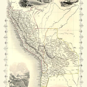
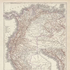
Photo Mug : Map of the northwestern part of South America, c.1900 (engraving)
")
")
![]()
Home Decor From Fine Art Finder
Map of the northwestern part of South America, c.1900 (engraving)
533259 Map of the northwestern part of South America, c.1900 (engraving); (add.info.: Map of northwest South America: Colombia, Venezuela, British Guiana, Ecuador, Peru, and Bolivia, circa 1902, from the 10th edition of Encyclopaedia Britannica.); Encyclopaedia Britannica/UIG
Media ID 38453920
© Encyclopaedia Britannica/UIG / Bridgeman Images
1902 19th Century Style Bolivia British Guiana Colombia Ecuador Geographical Border Guidance Illustration Technique Latinamerica Navigational Equipment Old Fashioned Pacific Ocean Part Of Peru Physical Geography Southamerica The Past Venezuela Western Script Americhe Latine America
Large Photo Mug (15 oz)
Sip your morning coffee in style with our Photo Mug featuring a vintage map of the northwestern part of South America from 1900. Perfect for history buffs and travel enthusiasts alike! ?️? #MediaStorehouse #PhotoMug #VintageMap
Elevate your coffee or tea experience with our premium white ceramic mug. Its wide, comfortable handle makes drinking easy, and you can rely on it to be both microwave and dishwasher safe. Sold in single units, preview may show both sides of the same mug so you can see how the picture wraps around.
Elevate your coffee or tea experience with our premium white ceramic mug. Its wide, comfortable handle makes drinking easy, and you can rely on it to be both microwave and dishwasher safe. Sold in single units, preview may show both sides of the same mug so you can see how the picture wraps around.
These are individually made so all sizes are approximate
FEATURES IN THESE COLLECTIONS
> Arts
> Artists
> O
> Oceanic Oceanic
> Maps and Charts
> Related Images
> South America
> Bolivia
> Maps
> South America
> Bolivia
> Related Images
> South America
> Colombia
> Maps
> South America
> Colombia
> Related Images
> South America
> Ecuador
> Maps
> South America
> Ecuador
> Related Images
> South America
> Peru
> Maps
EDITORS COMMENTS
This stunning engraving from c.1900 showcases a detailed map of the northwestern part of South America, including countries such as Colombia, Venezuela, British Guiana, Ecuador, Peru, and Bolivia. The intricate cartography and old-fashioned style transport us back to a time of exploration and discovery in this vibrant region.
The map is filled with geographical borders, coastlines, and navigational equipment that provide valuable guidance for travelers and explorers alike. The inclusion of the Pacific Ocean adds to the sense of adventure and vastness present in this beautifully crafted piece.
As we gaze upon this historical artifact from the 10th edition of Encyclopaedia Britannica, we are reminded of the rich history and cultural diversity that defines South America. The vertical orientation allows us to fully immerse ourselves in the intricacies of each country depicted on the map.
With no people present in the image, we are left to marvel at the sheer beauty and complexity of this part of Latin America. This engraving serves as a reminder of how far we have come in terms of mapping technology while also honoring the artistry and skill required to create such detailed illustrations.
MADE IN THE USA
Safe Shipping with 30 Day Money Back Guarantee
FREE PERSONALISATION*
We are proud to offer a range of customisation features including Personalised Captions, Color Filters and Picture Zoom Tools
SECURE PAYMENTS
We happily accept a wide range of payment options so you can pay for the things you need in the way that is most convenient for you
* Options may vary by product and licensing agreement. Zoomed Pictures can be adjusted in the Basket.