Photo Mug > Europe > United Kingdom > England > London > Museums > National Maritime Museum
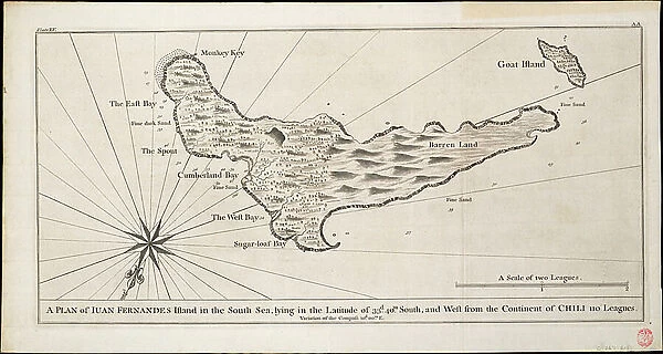
Photo Mug : A plan of Iuan Fernandes Island in the South Sea, lying in the latitude of 33d. 40m. south, and west from the continent of Chili 110 leagues, c.1750 (engraving)
![]()

Home Decor From Fine Art Finder
A plan of Iuan Fernandes Island in the South Sea, lying in the latitude of 33d. 40m. south, and west from the continent of Chili 110 leagues, c.1750 (engraving)
7339523 A plan of Iuan Fernandes Island in the South Sea, lying in the latitude of 33d. 40m. south, and west from the continent of Chili 110 leagues, c.1750 (engraving) by Anson, George (1697-1762); 53.5x28.5 cm; National Maritime Museum, London, UK; (add.info.: Creator: George Anson
Single sheet. Engraving. Scale: [circa 1:80 000 (bar)]. Cartographic Note: Ungraduated. North at 210 degrees. Scale in leagues. Plate XV from A Voyage Round the World by George Anson (1st edn 1748).); © National Maritime Museum, Greenwich, London
Media ID 38410034
© © National Maritime Museum, Greenwich, London / Bridgeman Images
Chile Chile Chilean Chilean Chilian Chilians Coast Line Excursion Explore Islands Isles Latin America Republic Of Chile Latine America
Large Photo Mug (15 oz)
Transport yourself to the South Sea with our Photo Mug featuring a vintage engraving of Juan Fernandes Island. Perfect for enjoying your favorite hot beverage while dreaming of exotic adventures.
Elevate your coffee or tea experience with our premium white ceramic mug. Its wide, comfortable handle makes drinking easy, and you can rely on it to be both microwave and dishwasher safe. Sold in single units, preview may show both sides of the same mug so you can see how the picture wraps around.
Elevate your coffee or tea experience with our premium white ceramic mug. Its wide, comfortable handle makes drinking easy, and you can rely on it to be both microwave and dishwasher safe. Sold in single units, preview may show both sides of the same mug so you can see how the picture wraps around.
These are individually made so all sizes are approximate
FEATURES IN THESE COLLECTIONS
> Fine Art Finder
> Artists
> George Anson
> Fine Art Finder
> Artists
> Samuel Thornton
> Animals
> Insects
> Hemiptera
> Black Scale
> Arts
> Artists
> W
> George White
> Europe
> United Kingdom
> England
> London
> Boroughs
> Greenwich
> Europe
> United Kingdom
> England
> London
> Museums
> Greenwich Heritage Centre
> Europe
> United Kingdom
> England
> London
> Museums
> National Maritime Museum
> Europe
> United Kingdom
> England
> London
> Towns
> Greenwich
> Europe
> United Kingdom
> Heritage Sites
> Maritime Greenwich
> Europe
> United Kingdom
> Maps
> Maps and Charts
> Early Maps
EDITORS COMMENTS
This engraving from the 18th century showcases a detailed plan of Juan Fernandes Island in the South Sea, located in the latitude of 33 degrees and 40 minutes south. The island lies west from the continent of Chile by 110 leagues, offering a glimpse into the intricate cartography of the time.
Created by George Anson, this engraving is part of his renowned work "A Voyage Round the World," first published in 1748. The scale on this map is approximately 1:80,000, with ungraduated measurements and north indicated at 210 degrees. The scale is represented in leagues, providing valuable information for navigation and exploration during that era.
The black and white depiction highlights the coastline of Juan Fernandes Island, showcasing its unique features and topography. As one delves into this historical artifact, they are transported back to a time when maritime exploration was at its peak, with expeditions venturing into unknown territories.
This print not only serves as a visual representation of geographical knowledge but also stands as a testament to human curiosity and perseverance in uncovering new lands. It captures the essence of discovery and adventure that defined an era marked by bold explorations across vast oceans.
MADE IN THE USA
Safe Shipping with 30 Day Money Back Guarantee
FREE PERSONALISATION*
We are proud to offer a range of customisation features including Personalised Captions, Color Filters and Picture Zoom Tools
SECURE PAYMENTS
We happily accept a wide range of payment options so you can pay for the things you need in the way that is most convenient for you
* Options may vary by product and licensing agreement. Zoomed Pictures can be adjusted in the Basket.


