Photo Mug > Arts > Artists > H > Johann Baptista Homann
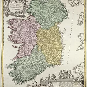
Photo Mug : Map of Ireland showing the Provinces of Ulster, Munster, Connaught and Leinster, by Johann B


![]()
Home Decor From Fine Art Finder
Map of Ireland showing the Provinces of Ulster, Munster, Connaught and Leinster, by Johann B
BAL42849 Map of Ireland showing the Provinces of Ulster, Munster, Connaught and Leinster, by Johann B. Homann, c.1730 (hand coloured engraving) by Homann, Johann Baptista (1663-1724); O Shea Gallery, London, UK; German, out of copyright
Media ID 12879770
© www.bridgemanimages.com
Large Photo Mug (15 oz)
Introducing the Media Storehouse Photo Mug, a unique and thoughtful gift that lets you carry your favorite memories with you everywhere. This mug features a stunning, hand-colored engraving of a Map of Ireland from the early 18th century, showcasing the provinces of Ulster, Munster, Connaught, and Leinster. The intricate details of this antique map, sourced from the renowned Bridgeman Images and Fine Art Finder, are sure to impress. Whether you're an Irish history enthusiast or simply appreciate the beauty of vintage maps, this mug is the perfect addition to your daily routine. Enjoy your favorite beverage while admiring the rich history and culture of Ireland, all in the palm of your hands.
Elevate your coffee or tea experience with our premium white ceramic mug. Its wide, comfortable handle makes drinking easy, and you can rely on it to be both microwave and dishwasher safe. Sold in single units, preview may show both sides of the same mug so you can see how the picture wraps around.
Elevate your coffee or tea experience with our premium white ceramic mug. Its wide, comfortable handle makes drinking easy, and you can rely on it to be both microwave and dishwasher safe. Sold in single units, preview may show both sides of the same mug so you can see how the picture wraps around.
These are individually made so all sizes are approximate
FEATURES IN THESE COLLECTIONS
> Animals
> Mammals
> Pitheciidae
> Baptista
> Arts
> Artists
> H
> Johann Baptista Homann
> Europe
> Republic of Ireland
> Maps
> Europe
> United Kingdom
> Maps
EDITORS COMMENTS
This print showcases a historic map of Ireland, meticulously crafted by Johann B. Homann in the early 18th century. The hand-coloured engraving beautifully depicts the four provinces of Ulster, Munster, Connaught, and Leinster that make up this enchanting island nation. Homann's attention to detail is evident as he intricately outlines each province with delicate precision. The vibrant hues used to highlight various geographical features add depth and character to the map. From the rugged coastlines to the rolling hills and expansive lakes, every element is brought to life through Homann's artistry. As we gaze upon this piece, we are transported back in time - a snapshot of Ireland during an era when cartography was both science and art. It serves as a reminder of how maps were not just tools for navigation but also works of beauty meant to inspire wonder and curiosity. Displayed at O Shea Gallery in London, UK, this print offers us a glimpse into Ireland's rich history and cultural heritage. It invites us to explore its diverse landscapes, delve into its storied past, and appreciate the craftsmanship behind such remarkable cartographic creations. With its timeless appeal and historical significance preserved through careful restoration efforts by Fine Art Finder at www. bridgemanimages. com , this Map of Ireland continues to captivate viewers today as it did centuries ago.
MADE IN THE USA
Safe Shipping with 30 Day Money Back Guarantee
FREE PERSONALISATION*
We are proud to offer a range of customisation features including Personalised Captions, Color Filters and Picture Zoom Tools
SECURE PAYMENTS
We happily accept a wide range of payment options so you can pay for the things you need in the way that is most convenient for you
* Options may vary by product and licensing agreement. Zoomed Pictures can be adjusted in the Basket.