Photo Mug > Europe > France > Paris > Maps
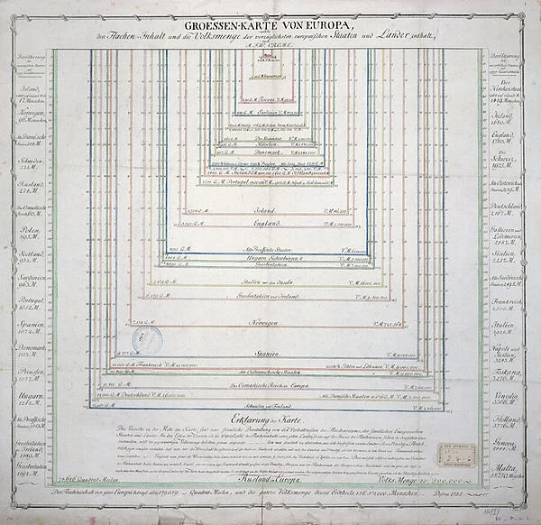
Photo Mug : German Map showing the extent of surface area and population of the principal countries
![]()

Home Decor From Fine Art Finder
German Map showing the extent of surface area and population of the principal countries
741282 German Map showing the extent of surface area and population of the principal countries of Europe, c.1785 (coloured engraving) (see also 741281) by French School, (18th century); Archives du Ministere des Affaires Etrangeres, Paris, France; (add.info.: Groessen Karte von Europa; ); French, out of copyright
Media ID 23165462
© Bridgeman Images
Carte Statistic Statistical Analysis Statistics Surface Area
Large Photo Mug (15 oz)
Bring history to your morning routine with our Media Storehouse Photo Mugs, featuring an intriguing German map from the Fine Art Finder archive. This beautifully detailed, 1785 engraving showcases the surface area and population of the principal countries in Europe, adding a touch of history and culture to your daily coffee or tea. The high-quality image is printed on both sides of the mug, allowing you to admire the intricate design from any angle. Perfect for history buffs, travel enthusiasts, or anyone who appreciates the beauty of fine art, our Photo Mugs make a unique and thoughtful gift. Embrace the past, one sip at a time.
Elevate your coffee or tea experience with our premium white ceramic mug. Its wide, comfortable handle makes drinking easy, and you can rely on it to be both microwave and dishwasher safe. Sold in single units, preview may show both sides of the same mug so you can see how the picture wraps around.
Elevate your coffee or tea experience with our premium white ceramic mug. Its wide, comfortable handle makes drinking easy, and you can rely on it to be both microwave and dishwasher safe. Sold in single units, preview may show both sides of the same mug so you can see how the picture wraps around.
These are individually made so all sizes are approximate
FEATURES IN THESE COLLECTIONS
> Fine Art Finder
> Artists
> French School
> Fine Art Finder
> Maps (celestial & Terrestrial)
> Europe
> France
> Paris
> Maps
> Maps and Charts
> Related Images
EDITORS COMMENTS
This colored engraving, titled "German Map showing the extent of surface area and population of the principal countries of Europe" offers a fascinating glimpse into 18th-century geography. Created by an anonymous French School artist in approximately 1785, this map showcases the vastness and diversity of European nations during that era. The intricate details on this print allow viewers to explore both the surface area and population statistics of each country depicted. From France to Russia, Spain to Sweden, every nation is meticulously outlined with vibrant colors that bring life to their borders. The map serves as a visual representation of Europe's political landscape at a time when boundaries were constantly shifting. Archived within the Ministry of Foreign Affairs in Paris, France, this historical artifact provides valuable insights into how Europeans perceived their continent over two centuries ago. It highlights not only geographical features but also statistical analysis—a testament to the intellectual curiosity prevalent during the Enlightenment period. As we gaze upon this remarkable piece from Bridgeman Images' collection, we are reminded of how far our understanding has evolved since its creation. Yet it remains an invaluable resource for historians and enthusiasts alike who seek a deeper comprehension of Europe's past and its enduring impact on our present world.
MADE IN THE USA
Safe Shipping with 30 Day Money Back Guarantee
FREE PERSONALISATION*
We are proud to offer a range of customisation features including Personalised Captions, Color Filters and Picture Zoom Tools
SECURE PAYMENTS
We happily accept a wide range of payment options so you can pay for the things you need in the way that is most convenient for you
* Options may vary by product and licensing agreement. Zoomed Pictures can be adjusted in the Basket.


