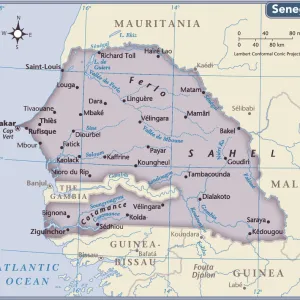
Photo Mug > Africa > Senegal > Maps
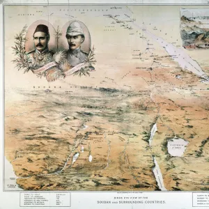
Photo Mug : Map of French expeditions in Africa, illustration from "Le Petit Journal"


![]()
Home Decor From Fine Art Finder
Map of French expeditions in Africa, illustration from "Le Petit Journal"
XEE4158968 Map of French expeditions in Africa, illustration from " Le Petit Journal" of March 5, 1894 (engraving) by French School, (19th century); Private Collection; Stefano Bianchetti; French, out of copyright
Media ID 22750038
© Stefano Bianchetti / Bridgeman Images
Congo Maghrebin Maghrebine Senegal Senegalese Geographical Map Maghreb Sudan
Large Photo Mug (15 oz)
Add a touch of history to your daily routine with our Media Storehouse Photo Mugs. Featuring an intriguing illustration from "Le Petit Journal" of March 5, 1894, this map of French expeditions in Africa is a captivating reminder of explorations past. With high-quality printing that brings the details of this engraving to life, each sip from this mug is an opportunity to delve into the rich history of French expeditions in Africa. Perfect for history buffs, travel enthusiasts, or anyone who appreciates the beauty of fine art, our Photo Mugs make a unique and thoughtful gift. Embrace the past, one mug at a time.
Elevate your coffee or tea experience with our premium white ceramic mug. Its wide, comfortable handle makes drinking easy, and you can rely on it to be both microwave and dishwasher safe. Sold in single units, preview may show both sides of the same mug so you can see how the picture wraps around.
Elevate your coffee or tea experience with our premium white ceramic mug. Its wide, comfortable handle makes drinking easy, and you can rely on it to be both microwave and dishwasher safe. Sold in single units, preview may show both sides of the same mug so you can see how the picture wraps around.
These are individually made so all sizes are approximate
FEATURES IN THESE COLLECTIONS
> Africa
> Senegal
> Related Images
> Africa
> Sudan
> Related Images
> Maps and Charts
> Related Images
EDITORS COMMENTS
This print showcases a historical map of French expeditions in Africa, as illustrated in the renowned publication "Le Petit Journal" on March 5,1894. The intricate engraving, created by an anonymous French School artist from the 19th century, offers a glimpse into the colonial era and geographical exploration of that time. The map encompasses various regions including Congo, Sudan, North Africa, and Senegal. It highlights the extensive road networks established by the French during their expeditions across Africa. This visual representation not only serves as a valuable tool for understanding African geography but also sheds light on France's colonial ambitions during this period. With vibrant colors and meticulous details characteristic of Stefano Bianchetti's private collection, this print captures the essence of African exploration intertwined with European imperialism. It invites viewers to delve into history and ponder upon the impact of colonialism on both continents. As we observe this remarkable piece of artistry from afar, it is important to acknowledge its significance beyond aesthetics. It symbolizes an era marked by cultural exchange and power dynamics between nations while reminding us to reflect critically on our shared past.
MADE IN THE USA
Safe Shipping with 30 Day Money Back Guarantee
FREE PERSONALISATION*
We are proud to offer a range of customisation features including Personalised Captions, Color Filters and Picture Zoom Tools
SECURE PAYMENTS
We happily accept a wide range of payment options so you can pay for the things you need in the way that is most convenient for you
* Options may vary by product and licensing agreement. Zoomed Pictures can be adjusted in the Basket.