Photo Mug > Arts > Artists > M > Mexican School Mexican School
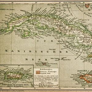
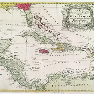
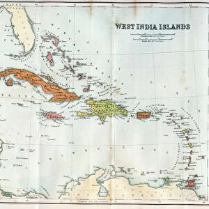
Photo Mug : New and accurate map of the West Indies (colour litho)
")
")
![]()
Home Decor From Fine Art Finder
New and accurate map of the West Indies (colour litho)
XCF274391 New and accurate map of the West Indies (colour litho) by American School; Private Collection; American, out of copyright.
possible copyright restrictions apply, consult national copyright laws
Media ID 18254569
© Private Collection / Bridgeman Images
Atlantic Ocean Bahamas Caribbean Sea Cartouche Geographical Gulf Of Mexico Islands Mapping Bahama Islands Caribbean Islands
Large Photo Mug (15 oz)
Add a touch of history and nautical charm to your daily routine with our Media Storehouse Photo Mugs. Featuring an exquisite, color lithograph of a New and Accurate Map of the West Indies by the American School, this mug showcases a captivating image from Bridgeman Images' Fine Art Finder collection. With an out-of-copyright status, this detailed map from the American School's Private Collection is a stunning addition to any mug. Sip your favorite beverage while admiring the rich history of the West Indies, as this mug brings a piece of the past into your present.
Elevate your coffee or tea experience with our premium white ceramic mug. Its wide, comfortable handle makes drinking easy, and you can rely on it to be both microwave and dishwasher safe. Sold in single units, preview may show both sides of the same mug so you can see how the picture wraps around.
Elevate your coffee or tea experience with our premium white ceramic mug. Its wide, comfortable handle makes drinking easy, and you can rely on it to be both microwave and dishwasher safe. Sold in single units, preview may show both sides of the same mug so you can see how the picture wraps around.
These are individually made so all sizes are approximate
FEATURES IN THESE COLLECTIONS
> Fine Art Finder
> Artists
> A
> American School American School
> Arts
> Artists
> M
> Mexican School Mexican School
> Arts
> Artists
> O
> Oceanic Oceanic
> Maps and Charts
> Related Images
> North America
> The Bahamas
> Maps
> North America
> The Bahamas
> Related Images
> North America
> Mexico
> Related Images
> South America
> Related Images
EDITORS COMMENTS
This vibrant and detailed print showcases a "New and accurate map of the West Indies" from the 19th century. The colour lithograph captures the beauty and intricacy of this historical cartographic masterpiece. The map encompasses an extensive area, including the Great Antilles, Bahamas, Caribbean Islands, South America, Atlantic Ocean, Gulf of Mexico, and more. It provides a comprehensive view of these tropical regions with precise geographical details. Intriguingly designed with a captivating cartouche at its center, this print is not only informative but also aesthetically pleasing. The intricate illustrations within the cartouche add an artistic touch to this scientific representation. As we delve into the rich history embedded in this artwork, it is important to note that it belongs to a private collection and is now out of copyright. However, potential copyright restrictions may still apply depending on national laws. This remarkable piece serves as both an educational tool for understanding past explorations and as a decorative item that adds character to any space. Whether you are fascinated by maps or simply appreciate fine art prints like this one from Fine Art Finder's collection at www. bridgemanimages. com - there is no denying that it offers a glimpse into our world's past while showcasing its undeniable beauty.
MADE IN THE USA
Safe Shipping with 30 Day Money Back Guarantee
FREE PERSONALISATION*
We are proud to offer a range of customisation features including Personalised Captions, Color Filters and Picture Zoom Tools
SECURE PAYMENTS
We happily accept a wide range of payment options so you can pay for the things you need in the way that is most convenient for you
* Options may vary by product and licensing agreement. Zoomed Pictures can be adjusted in the Basket.