Photo Mug > Africa > South Africa > Maps
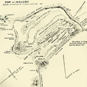
Photo Mug : Map Of Scene Of Action During The Battle Of Majuba Hill, Near Volksrust, South Africa, During The First Boer War. From The Book South Africa And The Transvaal War, Volume 1 By Louis Creswicke, Published 1900


![]()
Home Decor from Design Pics
Map Of Scene Of Action During The Battle Of Majuba Hill, Near Volksrust, South Africa, During The First Boer War. From The Book South Africa And The Transvaal War, Volume 1 By Louis Creswicke, Published 1900
Design Pics offers Distinctively Different Imagery representing over 1,500 contributors
Media ID 18191359
© Ken Welsh / Design Pics
Action Africa Battle Boer During First South Transvaal Majuba Volksrust
Large Photo Mug (15 oz)
Add a touch of history to your morning routine with our Media Storehouse Photo Mug, featuring an intriguing map of the Battle of Majuba Hill during the First Boer War. Taken from the classic book "South Africa And The Transvaal War, Volume 1" by Louis Creswicke, published in 1900, this detailed map transports you back in time. Each mug is expertly printed with high-quality images, ensuring your beverage stays hot while you savor the rich history etched into its design. Perfect for history enthusiasts, collectors, or anyone who appreciates the beauty of vintage maps, this unique mug makes a thoughtful gift or a treasured addition to your own collection.
Elevate your coffee or tea experience with our premium white ceramic mug. Its wide, comfortable handle makes drinking easy, and you can rely on it to be both microwave and dishwasher safe. Sold in single units, preview may show both sides of the same mug so you can see how the picture wraps around.
Elevate your coffee or tea experience with our premium white ceramic mug. Its wide, comfortable handle makes drinking easy, and you can rely on it to be both microwave and dishwasher safe. Sold in single units, preview may show both sides of the same mug so you can see how the picture wraps around.
These are individually made so all sizes are approximate
FEATURES IN THESE COLLECTIONS
> Africa
> South Africa
> Maps
> Africa
> South Africa
> Related Images
> Maps and Charts
> Related Images
EDITORS COMMENTS
This print showcases a historical map of the scene of action during the Battle of Majuba Hill, near Volksrust, South Africa. The image takes us back to the 19th century and immerses us in the intensity and significance of this battle that occurred during the First Boer War. The map provides a detailed layout of the terrain where this crucial conflict unfolded. It allows us to visualize the strategic positions held by both sides and understand how they influenced the outcome of the battle. With its intricate markings and annotations, it offers valuable insights into military tactics employed during that time. Published in 1900 as part of Louis Creswicke's book "South Africa And The Transvaal War" this print serves as a powerful visual representation of an important chapter in history. It transports us to an era when South Africa was embroiled in turmoil and upheaval. Ken Welsh's skillful capture ensures that every detail on this map is crisp and clear, allowing viewers to appreciate its historical significance fully. Whether you are a history enthusiast or simply intrigued by maps, this print is sure to captivate your imagination and spark curiosity about one of South Africa's most significant battles - The Battle of Majuba Hill.
MADE IN THE USA
Safe Shipping with 30 Day Money Back Guarantee
FREE PERSONALISATION*
We are proud to offer a range of customisation features including Personalised Captions, Color Filters and Picture Zoom Tools
SECURE PAYMENTS
We happily accept a wide range of payment options so you can pay for the things you need in the way that is most convenient for you
* Options may vary by product and licensing agreement. Zoomed Pictures can be adjusted in the Cart.