Mouse Mat > Historic > Ancient civilizations > Ancient Greece > Greek history
Mouse Mat : MAP / EUROPE / GREECE 323BC


![]()
Home Decor from Mary Evans Picture Library
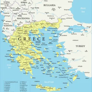
MAP / EUROPE / GREECE 323BC
THE EMPIRE OF ALEXANDER Date: 323 BC
Mary Evans Picture Library makes available wonderful images created for people to enjoy over the centuries
Media ID 20146111
© Bubblepunk
Mouse Pad
Standard Size Mouse Pad 7.75" x 9..25". High density Neoprene w linen surface. Easy to clean, stain resistant finish. Rounded corners.
Archive quality photographic print in a durable wipe clean mouse mat with non slip backing. Works with all computer mice
Estimated Image Size (if not cropped) is 23.7cm x 18.9cm (9.3" x 7.4")
Estimated Product Size is 23.7cm x 20.2cm (9.3" x 8")
These are individually made so all sizes are approximate
Artwork printed orientated as per the preview above, with landscape (horizontal) orientation to match the source image.
FEATURES IN THESE COLLECTIONS
> Mary Evans Prints Online
> New Images July 2020
> Europe
> Greece
> Related Images
> Europe
> Related Images
> Historic
> Ancient civilizations
> Ancient Greece
> Greek history
> Maps and Charts
> Related Images
EDITORS COMMENTS
This map print depicts the extent of the Macedonian Empire under the rule of Alexander the Great in 323 BC. The map focuses on Europe, with particular emphasis on the territories that fell under Alexander's control during his military campaigns. The map's intricate details reveal the vast expanse of Alexander's conquests, stretching from Greece in the south to the Danube River in the north, and from the Adriatic Sea in the west to the Indus River in the east. Alexander III of Macedon, also known as Alexander the Great, was a legendary military and political leader born in 356 BC in Pella, Macedonia. He succeeded his father, King Philip II of Macedon, in 336 BC and began his military career at the young age of 20. Over the next 13 years, Alexander would lead his army on a series of campaigns that would see him conquer much of the known world, including Persia, Egypt, and parts of Central Asia. The map illustrates the political divisions of Alexander's empire at the time of his death in 323 BC. The empire was divided among his generals, known as the Diadochi, who would go on to establish their own kingdoms, marking the beginning of the Hellenistic period. The map also highlights the major cities and regions that were under Alexander's control, including Athens, Sparta, Thebes, Thessaly, Thrace, Illyria, Macedonia, Epirus, Greece, Asia Minor, Syria, Egypt, Judea, and Mesopotamia. This map is an invaluable resource for anyone interested in ancient history, particularly the period of Alexander the Great and the Hellenistic world. Its intricate details and historical accuracy make it a must-have for scholars, educators, and history enthusiasts alike.
MADE IN THE USA
Safe Shipping with 30 Day Money Back Guarantee
FREE PERSONALISATION*
We are proud to offer a range of customisation features including Personalised Captions, Color Filters and Picture Zoom Tools
SECURE PAYMENTS
We happily accept a wide range of payment options so you can pay for the things you need in the way that is most convenient for you
* Options may vary by product and licensing agreement. Zoomed Pictures can be adjusted in the Cart.