Mouse Mat > Europe > United Kingdom > Wales > Maps
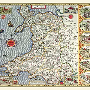
Mouse Mat : Old County Map of Caernarvonshire, Wales 1611 by John Speed


Home Decor From MapSeeker
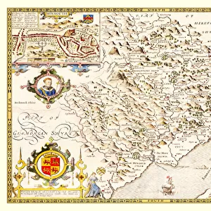
Old County Map of Caernarvonshire, Wales 1611 by John Speed
A facimile of John Speeds historical map of Caernarvonshire originally published for the " Theatre of the Empire of Great Britain", an atlas to accompany " a history of Great Britain"
Welcome to the Mapseeker Image library and enter an historic gateway to one of the largest on-line collections of Historic Maps, Nostalgic Views, Vista's and Panorama's from a World gone by.
Media ID 20348166
© Mapseeker Publishing Ltd
County Map County Map Of Wales Historic Map John Speed Map Old County Map Old Welsh County Map Speed Map Speede Map Welsh County Map Caernarvonshire
Mouse Pad
Standard Size Mouse Pad 7.75" x 9..25". High density Neoprene w linen surface. Easy to clean, stain resistant finish. Rounded corners.
Archive quality photographic print in a durable wipe clean mouse mat with non slip backing. Works with all computer mice
Estimated Image Size (if not cropped) is 23.7cm x 16.5cm (9.3" x 6.5")
Estimated Product Size is 23.7cm x 20.2cm (9.3" x 8")
These are individually made so all sizes are approximate
Artwork printed orientated as per the preview above, with landscape (horizontal) orientation to match the source image.
FEATURES IN THESE COLLECTIONS
> MapSeeker
> Maps from the British Isles
> Wales and Counties PORTFOLIO
> Arts
> Artists
> S
> John Speed
> Europe
> United Kingdom
> Wales
> Maps
> Europe
> United Kingdom
> Wales
> Posters
> Europe
> United Kingdom
> Wales
> Related Images
> Maps and Charts
> British Empire Maps
> Maps and Charts
> Early Maps
> Maps and Charts
> Wales
EDITORS COMMENTS
This print showcases an exquisite piece of history - the "Old County Map of Caernarvonshire, Wales 1611" by John Speed. A remarkable facsimile of Speed's original creation, this map was initially published for the renowned "Theatre of the Empire of Great Britain" an atlas designed to accompany a comprehensive account of Great Britain's rich history. Transporting us back in time, this old Welsh county map offers a fascinating glimpse into Caernarvonshire's past. With intricate details and meticulous craftsmanship, it reveals the geographical layout and boundaries that defined this region during the early 17th century. As we explore every inch of this historic treasure, we can almost hear echoes from centuries ago whispering stories about its people and their way of life. John Speed's name is synonymous with cartographic excellence, and his expertise shines through in this masterpiece. From quaint villages to majestic castles dotting the landscape, each element on this map tells a tale waiting to be discovered. It serves as a testament to both Speed's skill as a cartographer and his dedication to preserving historical knowledge for generations to come. Whether you are an avid historian or simply appreciate artistry in all its forms, this old county map is sure to captivate your imagination. Let it transport you through time as you unravel the secrets held within its borders - a true gem for any lover of maps or admirer of Wales' rich heritage.
MADE IN THE USA
Safe Shipping with 30 Day Money Back Guarantee
FREE PERSONALISATION*
We are proud to offer a range of customisation features including Personalised Captions, Color Filters and Picture Zoom Tools
SECURE PAYMENTS
We happily accept a wide range of payment options so you can pay for the things you need in the way that is most convenient for you
* Options may vary by product and licensing agreement. Zoomed Pictures can be adjusted in the Basket.