Mouse Mat > Europe > United Kingdom > Scotland > Maps
Mouse Mat : Early Coastal Survey Map of The West Coast of Scotland 1796


![]()
Home Decor From MapSeeker
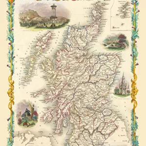
Early Coastal Survey Map of The West Coast of Scotland 1796
This is a colour reproduction of the attractive coastal chart of the West Coast of Scotland from the Firth of Clyde to Ardnamurchan originally produced by Stuart Amos Arnold
Welcome to the Mapseeker Image library and enter an historic gateway to one of the largest on-line collections of Historic Maps, Nostalgic Views, Vista's and Panorama's from a World gone by.
Media ID 20347999
Ardnamurchan Firth Of Clyde West Coast Of Scotland
Mouse Pad
Standard Size Mouse Pad 7.75" x 9..25". High density Neoprene w linen surface. Easy to clean, stain resistant finish. Rounded corners.
Archive quality photographic print in a durable wipe clean mouse mat with non slip backing. Works with all computer mice
Estimated Image Size (if not cropped) is 23.7cm x 16.5cm (9.3" x 6.5")
Estimated Product Size is 23.7cm x 20.2cm (9.3" x 8")
These are individually made so all sizes are approximate
Artwork printed orientated as per the preview above, with landscape (horizontal) orientation to match the source image.
FEATURES IN THESE COLLECTIONS
> MapSeeker
> Maps from the British Isles
> British Coastal Surveys PORTFOLIO
> MapSeeker
> Maps from the British Isles
> Scotland and Counties PORTFOLIO
> Europe
> United Kingdom
> Scotland
> Maps
> Maps and Charts
> Early Maps
EDITORS COMMENTS
This print showcases an exquisite colour reproduction of the Early Coastal Survey Map of The West Coast of Scotland, dating back to 1796. Originally crafted by the talented cartographer Stuart Amos Arnold, this coastal chart offers a fascinating glimpse into the maritime history and geographical features of Scotland's scenic western shoreline. Spanning from the majestic Firth of Clyde to Ardnamurchan, this meticulously detailed map provides a comprehensive overview of the region's coastal landscape. Its vibrant hues bring to life every intricate detail - from rugged cliffs and sandy beaches to charming fishing villages nestled along the shore. As we delve into this historical treasure, we are transported back in time, envisioning how sailors and explorers navigated these waters centuries ago. It serves as a testament to their bravery and determination in charting unknown territories amidst treacherous seas. The West Coast of Scotland has long been renowned for its breathtaking beauty and rich cultural heritage. This remarkable map allows us to appreciate its timeless allure while also serving as a valuable resource for historians, geographers, or anyone with an interest in Scottish maritime history. Whether displayed in homes or educational institutions, this stunning reproduction is sure to captivate viewers with its blend of artistry and historical significance. Let it transport you on an enchanting voyage through time as you explore the wonders that lie along Scotland's magnificent west coast.
MADE IN THE USA
Safe Shipping with 30 Day Money Back Guarantee
FREE PERSONALISATION*
We are proud to offer a range of customisation features including Personalised Captions, Color Filters and Picture Zoom Tools
SECURE PAYMENTS
We happily accept a wide range of payment options so you can pay for the things you need in the way that is most convenient for you
* Options may vary by product and licensing agreement. Zoomed Pictures can be adjusted in the Basket.