Mouse Mat > Arts > Artists > V > Jan Visscher
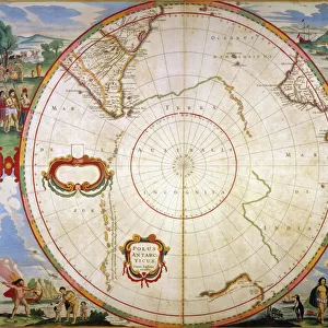
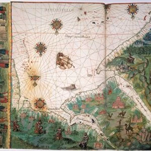
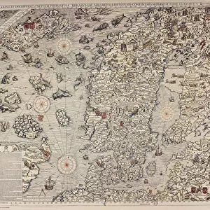
Mouse Mat : WORLD MAP, 17TH CENTURY. Nicols Visshers world map from Jan Janssons Novus Atlas, 1647-1662, with scenes from


![]()
Home Decor From Granger
WORLD MAP, 17TH CENTURY. Nicols Visshers world map from Jan Janssons Novus Atlas, 1647-1662, with scenes from
WORLD MAP, 17TH CENTURY. Nicols Visshers world map from Jan Janssons " Novus Atlas, " 1647-1662, with scenes from classical mythology
Granger holds millions of images spanning more than 25,000 years of world history, from before the Stone Age to the dawn of the Space Age
Media ID 6620147
Atlas Nicholas Visscher World Jansson
Mouse Pad
Standard Size Mouse Pad 7.75" x 9..25". High density Neoprene w linen surface. Easy to clean, stain resistant finish. Rounded corners.
Archive quality photographic print in a durable wipe clean mouse mat with non slip backing. Works with all computer mice
Estimated Product Size is 23.7cm x 20.2cm (9.3" x 8")
These are individually made so all sizes are approximate
Artwork printed orientated as per the preview above, with landscape (horizontal) or portrait (vertical) orientation to match the source image.
FEATURES IN THESE COLLECTIONS
> Granger Art on Demand
> Maps
> Arts
> Artists
> V
> Jan Visscher
> Arts
> Landscape paintings
> Waterfall and river artworks
> River artworks
> Maps and Charts
> Related Images
> Maps and Charts
> World
EDITORS COMMENTS
This print showcases a remarkable piece of cartographic history - the WORLD MAP, 17TH CENTURY. Nicols Visshers world map from Jan Janssons Novus Atlas, 1647-1662, with scenes from classical mythology. Created by The Granger Collection, this print takes us back to a time when exploration and discovery were at their peak. The intricate details of this map transport us to an era where the world was still being explored and understood. It depicts continents and countries as they were known in the 17th century, offering a glimpse into how our understanding of geography has evolved over time. What sets this particular map apart are the enchanting scenes from classical mythology that adorn its borders. These mythical vignettes add an element of wonder and intrigue to an already fascinating piece of art. As we gaze upon this print, we can't help but be reminded of the courage and curiosity that drove explorers like John Middle River Jansson Visscher to venture into uncharted territories. Their efforts paved the way for future generations to expand their knowledge and understanding of our vast planet. Whether you're a history enthusiast or simply appreciate beautiful artwork, this print is sure to captivate your imagination and transport you back in time. Let it serve as a reminder that there is always more to discover in our ever-changing world.
MADE IN THE USA
Safe Shipping with 30 Day Money Back Guarantee
FREE PERSONALISATION*
We are proud to offer a range of customisation features including Personalised Captions, Color Filters and Picture Zoom Tools
SECURE PAYMENTS
We happily accept a wide range of payment options so you can pay for the things you need in the way that is most convenient for you
* Options may vary by product and licensing agreement. Zoomed Pictures can be adjusted in the Basket.