Mouse Mat > North America > United States of America > Maps
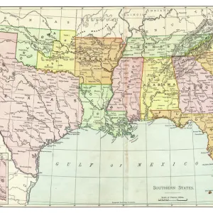
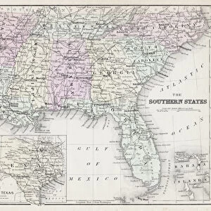
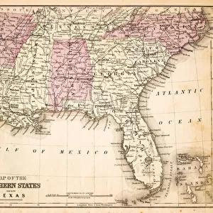
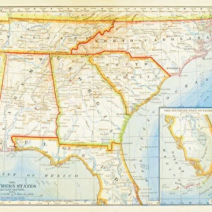
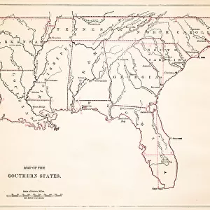
Mouse Mat : Map of USA southern states 1897


![]()
Home Decor From Fine Art Storehouse
Map of USA southern states 1897
Natural Elementary Geography by Redway and Hinman - NY/Cincinnati/Chicago 1897
Unleash your creativity and transform your space into a visual masterpiece!
THEPALMER
Media ID 20114797
© A 2014 Roberto Adrian Photography
Mouse Pad
Standard Size Mouse Pad 7.75" x 9..25". High density Neoprene w linen surface. Easy to clean, stain resistant finish. Rounded corners.
Archive quality photographic print in a durable wipe clean mouse mat with non slip backing. Works with all computer mice
Estimated Product Size is 23.7cm x 20.2cm (9.3" x 8")
These are individually made so all sizes are approximate
Artwork printed orientated as per the preview above, with landscape (horizontal) or portrait (vertical) orientation to match the source image.
FEATURES IN THESE COLLECTIONS
> Fine Art Storehouse
> Map
> Historical Maps
> Fine Art Storehouse
> Map
> USA Maps
> USA Southern States Historical Maps
> Fine Art Storehouse
> Map
> USA Maps
> Maps and Charts
> Related Images
> North America
> United States of America
> Maps
EDITORS COMMENTS
In this print titled "Map of USA southern states 1897" we are transported back in time to a pivotal era in American history. The map, originally featured in the renowned textbook "Natural Elementary Geography" by Redway and Hinman, takes us on a visual journey through the southern region of the United States during the late 19th century. With its intricate details and vibrant colors, this vintage map offers a fascinating glimpse into the geographical landscape that shaped America's past. From the bustling cities to the sprawling farmlands, each state is meticulously outlined, allowing us to trace our fingers along their borders as if retracing historic paths. As we explore this snapshot from yesteryears, it becomes evident that this piece holds more than just cartographic significance. It serves as a reminder of how education was once imparted through beautifully crafted textbooks like Redway and Hinman's masterpiece. This particular edition was published in New York City, Cincinnati, and Chicago in 1897 - an era when printed materials were cherished for their artistry as much as their educational value. "The Map of USA southern states 1897" transports us not only geographically but also emotionally. It evokes nostalgia for simpler times when maps were tangible objects held within one's hands rather than digital images on screens. Through THEPALMER's expertly captured photograph of this historical artifact available at Fine Art Storehouse, we can now bring home a piece of history and marvel at its beauty while appreciating its
MADE IN THE USA
Safe Shipping with 30 Day Money Back Guarantee
FREE PERSONALISATION*
We are proud to offer a range of customisation features including Personalised Captions, Color Filters and Picture Zoom Tools
SECURE PAYMENTS
We happily accept a wide range of payment options so you can pay for the things you need in the way that is most convenient for you
* Options may vary by product and licensing agreement. Zoomed Pictures can be adjusted in the Basket.