Mouse Mat > North America > United States of America > New York > New York > Maps
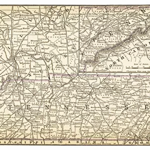
Mouse Mat : Map of Tennessee 1894


![]()
Home Decor From Fine Art Storehouse
Map of Tennessee 1894
Johnsons Universal Cyclopedia - Volume VIII New York - A. J. Johnson Company 1894
Unleash your creativity and transform your space into a visual masterpiece!
THEPALMER
Media ID 18356763
Mouse Pad
Standard Size Mouse Pad 7.75" x 9..25". High density Neoprene w linen surface. Easy to clean, stain resistant finish. Rounded corners.
Archive quality photographic print in a durable wipe clean mouse mat with non slip backing. Works with all computer mice
Estimated Image Size (if not cropped) is 23.7cm x 18cm (9.3" x 7.1")
Estimated Product Size is 23.7cm x 20.2cm (9.3" x 8")
These are individually made so all sizes are approximate
Artwork printed orientated as per the preview above, with landscape (horizontal) orientation to match the source image.
FEATURES IN THESE COLLECTIONS
> Maps and Charts
> Related Images
> North America
> United States of America
> New York
> New York
> Maps
> North America
> United States of America
> New York
> Related Images
EDITORS COMMENTS
In this print titled "Map of Tennessee 1894" we are transported back in time to the late 19th century, where cartography was both an art form and a scientific endeavor. The map, sourced from Johnson's Universal Cyclopedia - Volume VIII New York - A. J. Johnson Company 1894, showcases the intricate details and craftsmanship that went into creating these historical documents. The artist behind this remarkable print, known as THEPALMER, has skillfully captured the essence of Tennessee's geography during this era. Every contour and boundary line is meticulously rendered with precision and accuracy. As we explore the map, our eyes are drawn to its rich tapestry of cities, towns, rivers, mountains, and railroads that crisscross the state. Beyond being a mere representation of geographical features, this artwork serves as a window into Tennessee's past. It invites us to imagine what life was like for its inhabitants over a century ago – their journeys along winding roads or across vast landscapes; their reliance on waterways for trade and transportation; their connection to nature through majestic mountain ranges. "The Map of Tennessee 1894" offers not only aesthetic appeal but also educational value by allowing us to delve into history through visual storytelling. Whether you have personal ties to Tennessee or simply appreciate vintage maps as works of artistry themselves, this print will undoubtedly captivate your imagination while serving as a timeless reminder of our ever-changing world.
MADE IN THE USA
Safe Shipping with 30 Day Money Back Guarantee
FREE PERSONALISATION*
We are proud to offer a range of customisation features including Personalised Captions, Color Filters and Picture Zoom Tools
SECURE PAYMENTS
We happily accept a wide range of payment options so you can pay for the things you need in the way that is most convenient for you
* Options may vary by product and licensing agreement. Zoomed Pictures can be adjusted in the Basket.