Mouse Mat > Europe > France > Tours
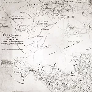
Mouse Mat : Map of Tibet and Central Asia of Mr. Prjevalskys journey - in "


![]()
Home Decor from Fine Art Finder
Map of Tibet and Central Asia of Mr. Prjevalskys journey - in "
LSE4104742 Map of Tibet and Central Asia of Mr. Prjevalskys journey - in " The World Tour", 1st week 1887 by French School, (19th century); Private Collection; (add.info.: Map of Tibet and Central Asia of Mr. Prjevalskys journey - in " The World Tour", 1st week 1887); Photo eLeonard de Selva; French, out of copyright
Media ID 23697438
© Leonard de Selva / Bridgeman Images
Tibet Asian Asian Geographical Map
Mouse Pad
Standard Size Mouse Pad 7.75" x 9..25". High density Neoprene w linen surface. Easy to clean, stain resistant finish. Rounded corners.
Archive quality photographic print in a durable wipe clean mouse mat with non slip backing. Works with all computer mice
Estimated Image Size (if not cropped) is 23.7cm x 16.5cm (9.3" x 6.5")
Estimated Product Size is 23.7cm x 20.2cm (9.3" x 8")
These are individually made so all sizes are approximate
Artwork printed orientated as per the preview above, with landscape (horizontal) orientation to match the source image.
FEATURES IN THESE COLLECTIONS
> Fine Art Finder
> Artists
> French School
> Fine Art Finder
> Artists
> Unknown Artist
> Asia
> Related Images
> Maps and Charts
> Related Images
> Maps and Charts
> World
> Popular Themes
> Tour De France
EDITORS COMMENTS
This print showcases a historical map titled "Map of Tibet and Central Asia of Mr. Prjevalskys journey - in 'The World Tour', 1st week 1887". Created by the French School in the 19th century, this engraving offers a fascinating glimpse into the geographical landscape of Tibet and Central Asia during that time. The intricate details depicted on this map provide valuable insights into the exploration undertaken by Mr. Prjevalsky, whose journey is highlighted within its borders. As we delve into this piece, we are transported back to an era when cartography was both an art form and a scientific endeavor. Through careful examination, one can observe the vastness of these regions and their interconnectedness with neighboring territories. The precision with which each mountain range, river system, and city is illustrated demonstrates the skillful craftsmanship employed by the French School. As we admire this remarkable work of art from Leonard de Selva's private collection, it serves as a reminder of how maps have played an essential role in our understanding of distant lands throughout history. This particular map not only provides geographic information but also invites us to embark on a virtual journey alongside Mr. Prjevalsky as he explored uncharted territories. Intriguingly blending artistry with knowledge, this photograph captures more than just lines on paper; it encapsulates adventure, discovery, and curiosity about far-off lands that continue to captivate our imaginations today.
MADE IN THE USA
Safe Shipping with 30 Day Money Back Guarantee
FREE PERSONALISATION*
We are proud to offer a range of customisation features including Personalised Captions, Color Filters and Picture Zoom Tools
FREE COLORIZATION SERVICE
You can choose advanced AI Colorization for this picture at no extra charge!
SECURE PAYMENTS
We happily accept a wide range of payment options so you can pay for the things you need in the way that is most convenient for you
* Options may vary by product and licensing agreement. Zoomed Pictures can be adjusted in the Cart.