Mouse Mat > Historic > Ancient civilizations > Roman Empire > Ancient Rome
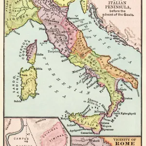
Mouse Mat : Geographic map showing the expansion of the Roman Empire. Colouring engraving from the 19th century


![]()
Home Decor From Fine Art Finder
Geographic map showing the expansion of the Roman Empire. Colouring engraving from the 19th century
NWI4863016 Geographic map showing the expansion of the Roman Empire. Colouring engraving from the 19th century.; (add.info.: Geographic map showing the expansion of the Roman Empire. Colouring engraving from the 19th century.); Photo © North Wind Pictures
Media ID 38166504
© © North Wind Pictures / Bridgeman Images
Mediterranean Sea Antique Rome Geographical Map
Mouse Pad
Standard Size Mouse Pad 7.75" x 9..25". High density Neoprene w linen surface. Easy to clean, stain resistant finish. Rounded corners.
Archive quality photographic print in a durable wipe clean mouse mat with non slip backing. Works with all computer mice
Estimated Image Size (if not cropped) is 23.7cm x 16.7cm (9.3" x 6.6")
Estimated Product Size is 23.7cm x 20.2cm (9.3" x 8")
These are individually made so all sizes are approximate
Artwork printed orientated as per the preview above, with landscape (horizontal) orientation to match the source image.
FEATURES IN THESE COLLECTIONS
> Fine Art Finder
> Artists
> Raymond de la Neziere
> Arts
> Artists
> R
> Roman Roman
> Europe
> Italy
> Lazio
> Rome
> Historic
> Ancient civilizations
> Roman Empire
> Ancient Rome
> Historic
> Ancient civilizations
> Roman Empire
> Roman art
> Maps and Charts
> Related Images
EDITORS COMMENTS
This stunning 19th-century engraving beautifully captures the expansion of the Roman Empire across Europe and North Africa. The intricate detailing and vibrant coloring bring to life the vast territories conquered by one of history's most powerful civilizations.
As you study this geographic map, you can trace the Roman Empire's reach from its origins in Italy to its farthest boundaries along the Mediterranean Sea. The empire's influence extended into regions that are now modern-day Spain, France, Greece, Turkey, Egypt, and beyond.
Each colored section on this map represents a different province or territory under Roman control, showcasing the empire's incredible size and diversity. From bustling cities to rural settlements, every corner of this vast domain played a role in shaping ancient history.
This engraving is not just a visual representation of geography; it is a testament to the ambition and military prowess of Rome as it expanded its borders through conquest and diplomacy. It serves as a reminder of how empires rise and fall over time but leave behind lasting legacies that continue to shape our world today.
Whether you're a history buff or simply appreciate fine artistry, this print is sure to captivate your imagination with its depiction of one of civilization's greatest achievements – the mighty Roman Empire.
MADE IN THE USA
Safe Shipping with 30 Day Money Back Guarantee
FREE PERSONALISATION*
We are proud to offer a range of customisation features including Personalised Captions, Color Filters and Picture Zoom Tools
SECURE PAYMENTS
We happily accept a wide range of payment options so you can pay for the things you need in the way that is most convenient for you
* Options may vary by product and licensing agreement. Zoomed Pictures can be adjusted in the Basket.