Mouse Mat > Arts > Modern art pieces > Textures and patterns in modern > Modern paintings
Mouse Mat : Sangoku tsuran zusetsu (Illustrated General Survey of the Three Countries)
")
![]()
Home Decor From Fine Art Finder
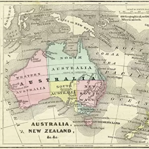
Sangoku tsuran zusetsu (Illustrated General Survey of the Three Countries)
3502614 Sangoku tsuran zusetsu (Illustrated General Survey of the Three Countries), 1785 (colour woodblock print) by Shihei, Hayashi (1738-93); Private Collection; (add.info.: SHIHEI, Hayashi (1738-1793). Sangoku tsuran zusetsu. (Illustrated General Survey of the Three Countries). Edo: Suharaya Ichibei, 5th of Temnei [1785].
Text volume: 4A (261 x 188 mm). Printed text including 22 single-page hand-colored wood-block illustrations and 5 double-page illustrations, two of which are printed verso to recto. Bound Japanese style, sewn with green thread over blue Japanese tissue wrappers; modern cloth folding box.
" Atlas" containing 5 folded manuscript maps in ink and color wash (some repairs with minor loss):
1. Japan overview. 730 x 518 mm (on heavier paper), bound between slate-colored diamond-patterned Japanese boards; boxed separately in modern cloth folding box.
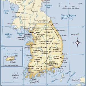
2. Eight Roads of Korea. 490 x 672 mm (laid down on heavier paper).
3. Ryukyu Islands. 538 x 725 mm (thin paper).
4. Islands North of Japan. 540 x 890 mm (thin paper).
5. Islands South of Tokyo. 280 x 550 mm (thin paper); boxed together with above three maps in modern cloth folding box; accompanied with original(?) oblong portfolio of red patterned-silk over boards with green silk ribbon ties.
EXCEEDINGLY RARE FIRST EDITION of Shiheis famous Sangoku Tsuran Zusetsu (Illustrated General Survey of the Three Countries), which describes Joseon Korea, the Ryukyu Kingdom, and Hokkaido--considered the most important geopolitical treatise of the period. It was one of the first Japanese works to relate Japan to its neighbors and as such was banned by the Edo government in 1792. It is considered one of the first modern attempts to define Japan compared to foreign nations, raising the question of external borders and the claim of some islands.
); Photo eChristies Images; Japanese, out of copyright
Media ID 23296552
© Christie's Images / Bridgeman Images
Atlas First Edition Joseon Korea Korean Manuscripts Mapping Rare Treatise Hokkaido
Mouse Pad
Standard Size Mouse Pad 7.75" x 9..25". High density Neoprene w linen surface. Easy to clean, stain resistant finish. Rounded corners.
Archive quality photographic print in a durable wipe clean mouse mat with non slip backing. Works with all computer mice
Estimated Image Size (if not cropped) is 17.9cm x 23.7cm (7" x 9.3")
Estimated Product Size is 20.2cm x 23.7cm (8" x 9.3")
These are individually made so all sizes are approximate
Artwork printed orientated as per the preview above, with portrait (vertical) orientation to match the source image.
FEATURES IN THESE COLLECTIONS
> Fine Art Finder
> Artists
> Hayashi Shihei
> Fine Art Finder
> Artists
> Joseph & Robin Robert (1741-99) Coteau
> Fine Art Finder
> Maps (celestial & Terrestrial)
> Arts
> Modern art pieces
> Textures and patterns in modern
> Modern paintings
> Arts
> Modern art pieces
> Textures and patterns in modern
> Asia
> Japan
> Related Images
> Asia
> South Korea
> Maps
> Asia
> South Korea
> Related Images
> Popular Themes
> North Island
EDITORS COMMENTS
This print showcases a rare and significant piece of Japanese history, the "Sangoku tsuran zusetsu (Illustrated General Survey of the Three Countries)" by Shihei, Hayashi. Created in 1785 as a color woodblock print, this artwork is part of a private collection. The illustrated text volume features hand-colored wood-block illustrations that depict various aspects of Joseon Korea, the Ryukyu Kingdom, and Hokkaido. It was one of the earliest works to explore Japan's relationship with its neighboring countries and was subsequently banned by the Edo government in 1792. Accompanying this remarkable publication are five folded manuscript maps meticulously drawn in ink and color wash. These maps provide an overview of Japan, highlight eight roads in Korea, showcase the Ryukyu Islands, display islands north of Japan, and present islands south of Tokyo. Considered an exceedingly rare first edition, this work holds immense historical value as it offers insights into geopolitical dynamics during that period. It raises questions about external borders and territorial claims over certain islands. Preserved within a modern cloth folding box alongside original silk-bound portfolios for added protection, this print serves as a testament to both artistic craftsmanship and scholarly pursuit. Its presence evokes curiosity about ancient cartography techniques while shedding light on early attempts to define Japan's position among foreign nations. (Photo: Bridgeman Images via Fine Art Finder)
MADE IN THE USA
Safe Shipping with 30 Day Money Back Guarantee
FREE PERSONALISATION*
We are proud to offer a range of customisation features including Personalised Captions, Color Filters and Picture Zoom Tools
SECURE PAYMENTS
We happily accept a wide range of payment options so you can pay for the things you need in the way that is most convenient for you
* Options may vary by product and licensing agreement. Zoomed Pictures can be adjusted in the Basket.