Mouse Mat > Animals > Mammals > Spalacidae > Antiquus
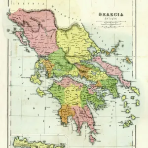
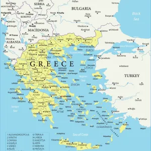
Mouse Mat : Map of Ancient Greece (coloured engraving)
")

![]()
Home Decor From Fine Art Finder
Map of Ancient Greece (coloured engraving)
7148249 Map of Ancient Greece (coloured engraving) by Kiepert, Heinrich (1818-99); Private Collection; (add.info.: Map of Ancient Greece. Illustration from Atlas Antiquus, Twelve Maps of the Ancient World for Schools and Colleges, by Dr Henry Kiepert (Dietrich Reimer, Berlin, c1889).); © Look and Learn
Media ID 25155158
© Look and Learn / Bridgeman Images
Atlas City Map City Plan Cretan Crete General Map Islands Isles Mediterranean Street Plan Greece Greek Mythological Figure Pagan Paganism Pagans Polytheism Polytheist
Mouse Pad
Standard Size Mouse Pad 7.75" x 9..25". High density Neoprene w linen surface. Easy to clean, stain resistant finish. Rounded corners.
Archive quality photographic print in a durable wipe clean mouse mat with non slip backing. Works with all computer mice
Estimated Product Size is 23.7cm x 20.2cm (9.3" x 8")
These are individually made so all sizes are approximate
Artwork printed orientated as per the preview above, with landscape (horizontal) or portrait (vertical) orientation to match the source image.
FEATURES IN THESE COLLECTIONS
> Fine Art Finder
> Artists
> Heinrich Kiepert
> Animals
> Mammals
> Spalacidae
> Antiquus
> Europe
> Greece
> Related Images
> Historic
> Ancient civilizations
> Ancient Greece
> Greek history
> Historic
> Ancient civilizations
> Ancient Greece
> Greek mythology
> Maps and Charts
> Early Maps
EDITORS COMMENTS
This coloured engraving, titled "Map of Ancient Greece" takes us back to the rich history and mythology of this ancient civilization. Created by Heinrich Kiepert in the 19th century, it is part of his renowned work Atlas Antiquus. The map showcases the intricate details of Greece's geography, with its islands and isles scattered across the Mediterranean Sea. From Crete to mainland Greece, every corner is meticulously depicted, offering a glimpse into the country's diverse landscape. But what truly brings this print to life are the mythological figures that adorn its borders. These mythical characters remind us of Greece's deep-rooted pagan beliefs and polytheistic religion. They serve as a reminder that Greek mythology played an integral role in shaping their culture and society. As we explore this enchanting map, we can't help but be transported back in time to an era filled with epic tales and legendary heroes. It serves as a testament to the enduring legacy of Ancient Greece and its influence on European history. Whether you're a lover of cartography or simply fascinated by ancient civilizations, this print offers a window into both historical accuracy and artistic beauty. With its vibrant colours and intricate engravings, it captures our imagination while providing valuable insights into one of humanity's most significant chapters: Ancient Greece.
MADE IN THE USA
Safe Shipping with 30 Day Money Back Guarantee
FREE PERSONALISATION*
We are proud to offer a range of customisation features including Personalised Captions, Color Filters and Picture Zoom Tools
SECURE PAYMENTS
We happily accept a wide range of payment options so you can pay for the things you need in the way that is most convenient for you
* Options may vary by product and licensing agreement. Zoomed Pictures can be adjusted in the Basket.