Mouse Mat > Arts > Artists > W > Charles White
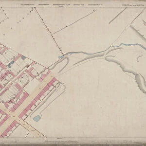
Mouse Mat : Carte de l invasion des Barbares (engraving)
")

![]()
Home Decor From Fine Art Finder
Carte de l invasion des Barbares (engraving)
7179745 Carte de l invasion des Barbares (engraving) by French School, (19th century); Private Collection; (add.info.: Carte de l invasion des Barbares. Illustration for L Habitation Humaine by Charles Garnier and A Ammann (Hachette, 1892).); © Look and Learn
Media ID 24688236
© Look and Learn / Bridgeman Images
Barbarian City Map City Plan General Map Habitations Human Person Invasion Living Lodgings Row Housing Street Plan Suburban Houses Dwelling Places
Mouse Pad
Standard Size Mouse Pad 7.75" x 9..25". High density Neoprene w linen surface. Easy to clean, stain resistant finish. Rounded corners.
Archive quality photographic print in a durable wipe clean mouse mat with non slip backing. Works with all computer mice
Estimated Image Size (if not cropped) is 23.7cm x 17cm (9.3" x 6.7")
Estimated Product Size is 23.7cm x 20.2cm (9.3" x 8")
These are individually made so all sizes are approximate
Artwork printed orientated as per the preview above, with landscape (horizontal) orientation to match the source image.
FEATURES IN THESE COLLECTIONS
> Fine Art Finder
> Artists
> American Photographer (after)
> Fine Art Finder
> Artists
> French School
> Arts
> Artists
> W
> Charles White
> Arts
> Realistic drawings
> Still life artwork
> Fine art
> Maps and Charts
> Early Maps
> Maps and Charts
> Related Images
EDITORS COMMENTS
This engraving from the 19th century, titled "Carte de l'invasion des Barbares" offers a glimpse into the historical context of human habitation during that era. The print showcases a detailed map depicting the invasion routes of various barbarian tribes. The intricate illustration was created by an anonymous French School artist and is part of a private collection. It originally served as an illustration for Charles Garnier and A Ammann's book "L'Habitation Humaine" published in 1892 by Hachette. The image portrays row housing, suburban houses, and lodgings that were prevalent during this time period. It provides insight into how people lived, highlighting their dwelling places and accommodations. The map itself serves as a general city plan or street plan, offering viewers an understanding of urban life at that time. This historical artifact sheds light on the challenges faced by communities due to invasions by barbarian tribes. Bridgeman Images has preserved this remarkable piece of history through its fine art collection. The engraving not only captures the essence of early 19th-century life but also invites us to reflect on our own living spaces today.
MADE IN THE USA
Safe Shipping with 30 Day Money Back Guarantee
FREE PERSONALISATION*
We are proud to offer a range of customisation features including Personalised Captions, Color Filters and Picture Zoom Tools
SECURE PAYMENTS
We happily accept a wide range of payment options so you can pay for the things you need in the way that is most convenient for you
* Options may vary by product and licensing agreement. Zoomed Pictures can be adjusted in the Basket.