Metal Print > Animals > Fishes > G > Grouper
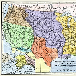
Metal Print : Map from 1898 showing the territorial growth of the United States of America


![]()
Metal Prints From Universal Images Group (UIG)
Map from 1898 showing the territorial growth of the United States of America
Map from 1898 showing the territorial growth of the United States of America. From The History of Our Country, published 1900
Universal Images Group (UIG) manages distribution for many leading specialist agencies worldwide
Media ID 20165289
© Ken Welsh / Design Pics
1898 Alaska America American Century Country Danish Denmark Expansion Growth Kingdom Louisiana Mexican Mexico Nineteenth Original Russian Spain Spanish State States Territorial Territory Texas Thirteen Treaty United Annexation Annexes Cession Conquests Purchase Purchases
16"x20" (51x41cm) Metal Print
Step back in time with our stunning Metal Prints from Media Storehouse, featuring this captivating map from 1898. Witness the territorial growth of the United States of America as it appeared in The History of Our Country, published in 1900. This vintage map, sourced from Universal History Archive at Universal Images Group (UIG), is meticulously reproduced on high-quality metal for a vibrant, long-lasting display. Add a touch of history and character to your home or office decor with this intriguing piece of American history.
Made with durable metal and luxurious printing techniques, our metal photo prints go beyond traditional canvases, adding a cool, modern touch to your space. Wall mount on back. Eco-friendly 100% post-consumer recycled ChromaLuxe aluminum surface. The thickness of the print is 0.045". Featuring a Scratch-resistant surface and Rounded corners. Backing hangers are attached to the back of the print and float the print 1/2-inch off the wall when hung, the choice of hanger may vary depending on size and International orders will come with Float Mount hangers only. Finished with a brilliant white high gloss surface for unsurpassed detail and vibrance. Printed using Dye-Sublimation and for best care we recommend a non-ammonia glass cleaner, water, or isopropyl (rubbing) alcohol to prevent harming the print surface. We recommend using a clean, lint-free cloth to wipe off the print. The ultra-hard surface is scratch-resistant, waterproof and weatherproof. Avoid direct sunlight exposure.
Made with durable metal and luxurious printing techniques, metal prints bring images to life and add a modern touch to any space
Estimated Image Size (if not cropped) is 50.8cm x 40.6cm (20" x 16")
Estimated Product Size is 51.4cm x 41.2cm (20.2" x 16.2")
These are individually made so all sizes are approximate
Artwork printed orientated as per the preview above, with landscape (horizontal) orientation to match the source image.
FEATURES IN THESE COLLECTIONS
> Animals
> Fishes
> G
> Grouper
> Europe
> Denmark
> Related Images
> Europe
> Russia
> Related Images
> Europe
> United Kingdom
> England
> Maps
> Universal Images Group (UIG)
> History
> Historical Maps
> Universal Images Group (UIG)
> Universal Images Group
> Universal History Archive
> History
EDITORS COMMENTS
This print showcases a remarkable map from 1898, unveiling the extraordinary territorial growth of the United States of America. A true testament to the nation's expansionist spirit, this historical artifact traces the country's journey towards becoming a vast and diverse landmass. From its humble beginnings as thirteen original states, this map vividly illustrates how America acquired new territories through conquests, purchases, and annexations. The cartographic masterpiece highlights significant milestones in American history such as the Louisiana Purchase, which doubled the size of the nation overnight. It also includes Texas' annexation and Alaska's acquisition from Russia – both pivotal moments that shaped America's geography. Through treaties with various European powers like Spain and France, Britain and Denmark, these lands were added to an ever-growing United States. The Mexican Cession following a war with Mexico further expanded America's borders southwards. As we gaze upon this intricate illustration from over a century ago, it serves as a powerful reminder of our nation's relentless pursuit for progress and manifest destiny. This map not only captures geographical changes but also symbolizes the resilience and ambition that define us as Americans. With each territory gained on this mesmerizing map comes stories untold – tales of exploration, settlement, conflict, cultural exchange - all contributing to shaping what we know today as one united country: The United States of America.
MADE IN THE USA
Safe Shipping with 30 Day Money Back Guarantee
FREE PERSONALISATION*
We are proud to offer a range of customisation features including Personalised Captions, Color Filters and Picture Zoom Tools
SECURE PAYMENTS
We happily accept a wide range of payment options so you can pay for the things you need in the way that is most convenient for you
* Options may vary by product and licensing agreement. Zoomed Pictures can be adjusted in the Basket.