Metal Print > Universal Images Group (UIG) > Art > Painting, Sculpture & Prints > Cartography
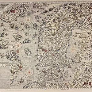
Metal Print : Finland and Russian territories, from Carta Marina, Sea Map by Olaus Magnus, Venice, detail, 1539


![]()
Metal Prints from Universal Images Group (UIG)
Finland and Russian territories, from Carta Marina, Sea Map by Olaus Magnus, Venice, detail, 1539
Cartography, 16th century. Finland and Russian territories. From Carta Marina (Sea Map) by Olaus Magnus, Venice, 1539. Detail
Universal Images Group (UIG) manages distribution for many leading specialist agencies worldwide
Media ID 9571547
© DEA / M. SEEMULLER
16th Century Coastline Estonia Finland Guidance Gulf Sailing Ship Olaus Magnus
16"x20" (51x41cm) Metal Print
Discover the rich history of cartography with our Media Storehouse Metal Print of the intricately detailed map, "Carta Marina" by Olaus Magnus. This stunning 16th-century masterpiece, published in Venice in 1539, showcases the Finland and Russian territories as they were known during that era. The metal print's vibrant colors and sharp contrasts bring out the intricate cartographic details, making it a captivating addition to any room. Travel back in time and explore the fascinating world of ancient cartography with this beautiful piece of art.
Made with durable metal and luxurious printing techniques, our metal photo prints go beyond traditional canvases, adding a cool, modern touch to your space. Wall mount on back. Eco-friendly 100% post-consumer recycled ChromaLuxe aluminum surface. The thickness of the print is 0.045". Featuring a Scratch-resistant surface and Rounded corners. Backing hangers are attached to the back of the print and float the print 1/2-inch off the wall when hung, the choice of hanger may vary depending on size and International orders will come with Float Mount hangers only. Finished with a brilliant white high gloss surface for unsurpassed detail and vibrance. Printed using Dye-Sublimation and for best care we recommend a non-ammonia glass cleaner, water, or isopropyl (rubbing) alcohol to prevent harming the print surface. We recommend using a clean, lint-free cloth to wipe off the print. The ultra-hard surface is scratch-resistant, waterproof and weatherproof. Avoid direct sunlight exposure.
Made with durable metal and luxurious printing techniques, metal prints bring images to life and add a modern touch to any space
Estimated Image Size (if not cropped) is 50.8cm x 40.6cm (20" x 16")
Estimated Product Size is 51.4cm x 41.2cm (20.2" x 16.2")
These are individually made so all sizes are approximate
Artwork printed orientated as per the preview above, with landscape (horizontal) orientation to match the source image.
EDITORS COMMENTS
This print showcases a stunning detail from the historic Carta Marina, a sea map created by Olaus Magnus in 1539. The focus of this particular section is Finland and Russian territories, offering us a glimpse into the cartography of the 16th century. The intricate illustration and painting on this map provide invaluable insights into the geography and history of Europe during that era. With its horizontal orientation, it allows viewers to immerse themselves in the vastness of these lands. As we explore this image, our eyes are drawn to the Gulf of Finland, which separates these two regions. The coastline stretches out before us with remarkable accuracy for its time, highlighting key landmarks such as Estonia. This detailed depiction serves as both guidance and inspiration for travel enthusiasts or those interested in maritime history. It transports us back to a time when sailing ships dominated these waters, evoking a sense of adventure and discovery. Although devoid of people, this print speaks volumes about the significant role played by cartographers like Olaus Magnus in documenting our world's ever-changing landscapes. Its historical significance cannot be overstated. In summary, this mesmerizing print offers an extraordinary glimpse into 16th-century cartography through Olaus Magnus' masterpiece - Carta Marina. It invites us to appreciate not only the beauty but also the importance of maps as tools for exploration and understanding our past.
MADE IN THE USA
Safe Shipping with 30 Day Money Back Guarantee
FREE PERSONALISATION*
We are proud to offer a range of customisation features including Personalised Captions, Color Filters and Picture Zoom Tools
SECURE PAYMENTS
We happily accept a wide range of payment options so you can pay for the things you need in the way that is most convenient for you
* Options may vary by product and licensing agreement. Zoomed Pictures can be adjusted in the Cart.