Metal Print > Maps and Charts > Related Images
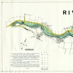
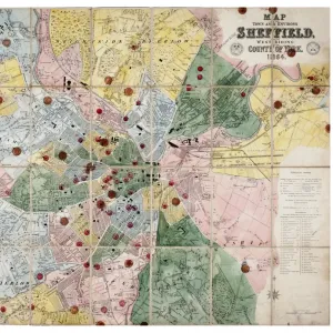
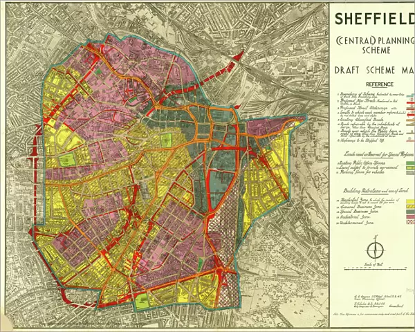
Metal Print : Sheffield (Central) Planning Scheme; Draft Scheme Map, 1939
 Planning Scheme; Draft Scheme Map, 1939")

Resolution may be poor at this size (119 DPI)
![]()
Metal Prints from Sheffield City Archives
Sheffield (Central) Planning Scheme; Draft Scheme Map, 1939
Published by Sheffield City Council.Scale 200 feet : 1 inch.Original at Sheffield Local Studies Library:s (39) L
Sheffield City Archives and Local Studies Library has an unrivalled collection of images of Sheffield, England
Media ID 14051584
© Sheffield City Council
16"x20" (51x41cm) Metal Print
Step back in time with our Media Storehouse Metal Print featuring the Sheffield (Central) Planning Scheme Draft Scheme Map from 1939. This historic map, published by Sheffield City Council, offers a unique glimpse into the city's past planning efforts. With meticulous detail and a scale of 200 feet to 1 inch, this vintage map is a must-have for history enthusiasts, urban planners, and anyone with an appreciation for Sheffield's rich heritage. Printed on high-quality metal, this print is not only visually stunning but also durable and long-lasting. Bring a piece of Sheffield's history into your home or office with our Metal Print of the Central Planning Scheme Map, 1939.
Made with durable metal and luxurious printing techniques, our metal photo prints go beyond traditional canvases, adding a cool, modern touch to your space. Wall mount on back. Eco-friendly 100% post-consumer recycled ChromaLuxe aluminum surface. The thickness of the print is 0.045". Featuring a Scratch-resistant surface and Rounded corners. Backing hangers are attached to the back of the print and float the print 1/2-inch off the wall when hung, the choice of hanger may vary depending on size and International orders will come with Float Mount hangers only. Finished with a brilliant white high gloss surface for unsurpassed detail and vibrance. Printed using Dye-Sublimation and for best care we recommend a non-ammonia glass cleaner, water, or isopropyl (rubbing) alcohol to prevent harming the print surface. We recommend using a clean, lint-free cloth to wipe off the print. The ultra-hard surface is scratch-resistant, waterproof and weatherproof. Avoid direct sunlight exposure.
Made with durable metal and luxurious printing techniques, metal prints bring images to life and add a modern touch to any space
Estimated Image Size (if not cropped) is 50.8cm x 40.6cm (20" x 16")
Estimated Product Size is 51.4cm x 41.2cm (20.2" x 16.2")
These are individually made so all sizes are approximate
Artwork printed orientated as per the preview above, with landscape (horizontal) orientation to match the source image.
FEATURES IN THESE COLLECTIONS
> Maps and Charts
> Related Images
> Sheffield City Archives
> Maps and Plans
EDITORS COMMENTS
This print showcases the Sheffield (Central) Planning Scheme's Draft Scheme Map from 1939. Published by the esteemed Sheffield City Council, this historical document offers a glimpse into the city's urban planning efforts during that era. The scale of 200 feet to 1 inch provides intricate details and highlights the meticulousness with which this plan was crafted. Preserved at the prestigious Sheffield Local Studies Library, this original piece holds immense value for researchers and history enthusiasts alike. It serves as a testament to the dedication and foresight of city planners who sought to shape Sheffield's future development. The map itself is a visual feast, revealing an intricate network of streets, buildings, parks, and landmarks that formed the foundation of central Sheffield in 1939. Every street corner tells a story; every block represents countless hours of thoughtful consideration. As we gaze upon this remarkable artifact from yesteryears, it transports us back in time – allowing us to appreciate how far our beloved city has come since then. It reminds us that progress is built upon visionary plans like these and encourages us to reflect on how we can continue shaping our urban landscape for future generations
MADE IN THE USA
Safe Shipping with 30 Day Money Back Guarantee
FREE PERSONALISATION*
We are proud to offer a range of customisation features including Personalised Captions, Color Filters and Picture Zoom Tools
SECURE PAYMENTS
We happily accept a wide range of payment options so you can pay for the things you need in the way that is most convenient for you
* Options may vary by product and licensing agreement. Zoomed Pictures can be adjusted in the Cart.