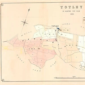
Metal Print > Europe > United Kingdom > England > Yorkshire > Totley
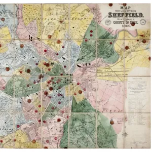
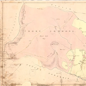
Metal Print : Totley enclosure map, 1842


![]()
Metal Prints from Sheffield City Archives
Totley enclosure map, 1842
By George Sanderson, surveyor of Mansfield.
From an original at Sheffield Libraries: arc02952
Sheffield City Archives and Local Studies Library has an unrivalled collection of images of Sheffield, England
Media ID 19042486
© Sheffield City Council
16"x24" (61x41cm) Metal Print
Step back in time with our exquisite Metal Print of the Totley Enclosure Map from 1842. This captivating piece, sourced from Sheffield City Archives, showcases the intricate details of the Totley Enclosure Map, meticulously surveyed by George Sanderson of Mansfield. Each Metal Print is crafted using premium quality materials, resulting in a vibrant and long-lasting image that adds an air of history and sophistication to any space. Bring the rich heritage of Sheffield into your home or office with this unique and stunning addition to your decor.
Made with durable metal and luxurious printing techniques, our metal photo prints go beyond traditional canvases, adding a cool, modern touch to your space. Wall mount on back. Eco-friendly 100% post-consumer recycled ChromaLuxe aluminum surface. The thickness of the print is 0.045". Featuring a Scratch-resistant surface and Rounded corners. Backing hangers are attached to the back of the print and float the print 1/2-inch off the wall when hung, the choice of hanger may vary depending on size and International orders will come with Float Mount hangers only. Finished with a brilliant white high gloss surface for unsurpassed detail and vibrance. Printed using Dye-Sublimation and for best care we recommend a non-ammonia glass cleaner, water, or isopropyl (rubbing) alcohol to prevent harming the print surface. We recommend using a clean, lint-free cloth to wipe off the print. The ultra-hard surface is scratch-resistant, waterproof and weatherproof. Avoid direct sunlight exposure.
Made with durable metal and luxurious printing techniques, metal prints bring images to life and add a modern touch to any space
Estimated Product Size is 61.5cm x 41.2cm (24.2" x 16.2")
These are individually made so all sizes are approximate
Artwork printed orientated as per the preview above, with landscape (horizontal) orientation to match the source image.
FEATURES IN THESE COLLECTIONS
> Europe
> United Kingdom
> England
> Yorkshire
> Related Images
> Europe
> United Kingdom
> England
> Yorkshire
> Sheffield
> Europe
> United Kingdom
> England
> Yorkshire
> Totley
> Maps and Charts
> Related Images
> Sheffield City Archives
> Maps and Plans
> Maps of Derbyshire
> Sheffield City Archives
> Maps and Plans
> Maps of Sheffield
Totley Enclosure Map, 1842 - A Glimpse into the Past
EDITORS COMMENTS
. Step back in time with this print of the Totley enclosure map from 1842. Crafted by George Sanderson, a skilled surveyor from Mansfield, this remarkable piece offers a fascinating insight into the historical landscape of Totley, Derbyshire. Preserved at Sheffield Libraries and now available for your viewing pleasure through Sheffield City Archives (arc02952), this rare gem takes you on an immersive journey to a bygone era. Immerse yourself in the intricate details meticulously captured by Sanderson's expert hand. The map showcases every nook and cranny of Totley, providing an invaluable resource for historians, researchers, and those simply curious about their local heritage. From sprawling fields to quaint hamlets nestled amidst picturesque hillsides; every element is carefully plotted to offer a comprehensive understanding of Totley's past. As you delve deeper into its intricacies, allow yourself to imagine life as it once was in this charming corner of Yorkshire. Picture farmers tending their crops under vast open skies or villagers going about their daily routines along winding lanes that still exist today. This visual treasure trove serves as a testament to the enduring spirit and rich history that shaped Totley over centuries. Whether you are an avid historian or merely captivated by tales from yesteryears, let this extraordinary print transport you back in time as you explore the enchanting world within its borders. Discover Totley
MADE IN THE USA
Safe Shipping with 30 Day Money Back Guarantee
FREE PERSONALISATION*
We are proud to offer a range of customisation features including Personalised Captions, Color Filters and Picture Zoom Tools
SECURE PAYMENTS
We happily accept a wide range of payment options so you can pay for the things you need in the way that is most convenient for you
* Options may vary by product and licensing agreement. Zoomed Pictures can be adjusted in the Cart.
![Map of Woodthorpe Hall Farm [Holmesfield] in the parish of Dronfield, County of Derby, 1736](/sq/716/map-woodthorpe-hall-farm-holmesfield-parish-18987347.jpg.webp)