Metal Print > Europe > United Kingdom > Wales > Maps
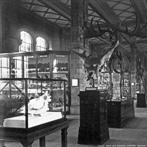
Metal Print : William Smiths Geological Map


![]()
Metal Prints from Mary Evans Picture Library
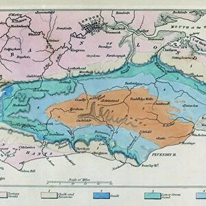
William Smiths Geological Map
Fig. 6 from Delineation of Strata of England and Wales (1815) by William Smith
Mary Evans Picture Library makes available wonderful images created for people to enjoy over the centuries
Media ID 8603753
© Mary Evans Picture Library 2015 - https://copyrighthub.org/s0/hub1/creation/maryevans/MaryEvansPictureID/10710929
1769 1839 Geological Geological Map Geology Great Britain Strata Stratification William Smith Smith
16"x24" (61x41cm) Metal Print
Introducing the Media Storehouse Metal Prints, featuring an exquisite image of William Smith's iconic geological map from Mary Evans Prints Online (Fig. 6 from Delineation of Strata of England and Wales, 1815). This stunning metal print showcases the intricate details of Smith's groundbreaking work, which revolutionized the field of geology. Each print is meticulously crafted using high-quality metal sheets, ensuring a vibrant and long-lasting display. Bring a piece of historical scientific discovery into your home or office with this beautiful and unique addition to your decor.
Made with durable metal and luxurious printing techniques, our metal photo prints go beyond traditional canvases, adding a cool, modern touch to your space. Wall mount on back. Eco-friendly 100% post-consumer recycled ChromaLuxe aluminum surface. The thickness of the print is 0.045". Featuring a Scratch-resistant surface and Rounded corners. Backing hangers are attached to the back of the print and float the print 1/2-inch off the wall when hung, the choice of hanger may vary depending on size and International orders will come with Float Mount hangers only. Finished with a brilliant white high gloss surface for unsurpassed detail and vibrance. Printed using Dye-Sublimation and for best care we recommend a non-ammonia glass cleaner, water, or isopropyl (rubbing) alcohol to prevent harming the print surface. We recommend using a clean, lint-free cloth to wipe off the print. The ultra-hard surface is scratch-resistant, waterproof and weatherproof. Avoid direct sunlight exposure.
Made with durable metal and luxurious printing techniques, metal prints bring images to life and add a modern touch to any space
Estimated Product Size is 41.2cm x 61.5cm (16.2" x 24.2")
These are individually made so all sizes are approximate
Artwork printed orientated as per the preview above, with portrait (vertical) orientation to match the source image.
FEATURES IN THESE COLLECTIONS
> Arts
> Artists
> S
> Mary Smith
> Europe
> Related Images
> Europe
> United Kingdom
> England
> Maps
> Europe
> United Kingdom
> England
> Posters
> Europe
> United Kingdom
> England
> Related Images
> Europe
> United Kingdom
> Wales
> Maps
> Europe
> United Kingdom
> Wales
> Posters
> Europe
> United Kingdom
> Wales
> Related Images
> Maps and Charts
> Geological Map
> Maps and Charts
> Related Images
EDITORS COMMENTS
1. Title: A Landmark in the History of Geology: William Smith's Groundbreaking Geological Map of England and Wales (1815) Fig. 6 from Delineation of Strata of England and Wales, published by the renowned geologist William Smith in 1815, represents a pivotal moment in the development of geological science. This map, showcased here, revolutionized the understanding of the geology of England and Wales, and significantly influenced the European scientific community. William Smith (1769-1839), a self-taught geologist, is celebrated for his innovative approach to studying the Earth's subsurface. He recognized the importance of identifying the stratigraphic relationships between different rock formations, a concept known as stratification. Smith's map was the first comprehensive attempt to depict the various rock strata across England and Wales, providing a visual representation of the geological history of the region. The map's intricate details reveal the distribution of various rock types, from limestone to sandstone, shale, and coal, and the relationships between them. The strata are color-coded, with each color representing a specific rock type or formation. This innovative use of color-coding laid the foundation for modern geological mapping techniques. Smith's Geological Map of England and Wales not only advanced the field of geology but also had significant implications for industries such as mining, engineering, and construction. The map's accuracy and detail allowed for the identification of valuable mineral deposits, the assessment of potential building sites, and the understanding of the subsurface conditions that could influence infrastructure projects. This evocative print, taken from Mary Evans Prints Online, offers a glimpse into the rich history of geology and the groundbreaking work of William Smith. His map remains an enduring testament to the power of human curiosity and the pursuit of knowledge.
MADE IN THE USA
Safe Shipping with 30 Day Money Back Guarantee
FREE PERSONALISATION*
We are proud to offer a range of customisation features including Personalised Captions, Color Filters and Picture Zoom Tools
SECURE PAYMENTS
We happily accept a wide range of payment options so you can pay for the things you need in the way that is most convenient for you
* Options may vary by product and licensing agreement. Zoomed Pictures can be adjusted in the Cart.