Metal Print > Arts > Artists > O > Oceanic Oceanic
Metal Print : Strategic importance of Crete and Cyprus by G. H. Davis


![]()
Metal Prints From Mary Evans Picture Library
Strategic importance of Crete and Cyprus by G. H. Davis
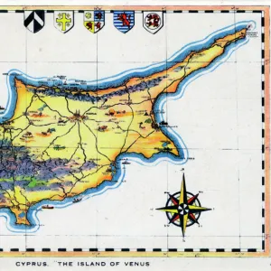
The Eastern Mediterranean: maps showing the strategic importance of Crete and Cyprus during the Second World War. Date: 1941
Mary Evans Picture Library makes available wonderful images created for people to enjoy over the centuries
Media ID 14125625
© Illustrated London News Ltd/Mary Evans
1941 Crete Cyprus Davis Importance Important Maps Mediterranean Strategic Strategy
16"x24" (61x41cm) Metal Print
Add a piece of historical art to your home or office with our Media Storehouse Metal Print of "The Eastern Mediterranean: Maps Showing the Strategic Importance of Crete and Cyprus during the Second World War" by G. H. Davis. This captivating image, sourced from Mary Evans Prints Online, provides a fascinating insight into the geopolitical landscape of the Eastern Mediterranean during wartime. The intricate details of the map are beautifully rendered on high-quality metal, creating a vibrant and durable piece that is sure to be a conversation starter. Bring a piece of history into your space and elevate your decor with this unique and thought-provoking metal print.
Made with durable metal and luxurious printing techniques, our metal photo prints go beyond traditional canvases, adding a cool, modern touch to your space. Wall mount on back. Eco-friendly 100% post-consumer recycled ChromaLuxe aluminum surface. The thickness of the print is 0.045". Featuring a Scratch-resistant surface and Rounded corners. Backing hangers are attached to the back of the print and float the print 1/2-inch off the wall when hung, the choice of hanger may vary depending on size and International orders will come with Float Mount hangers only. Finished with a brilliant white high gloss surface for unsurpassed detail and vibrance. Printed using Dye-Sublimation and for best care we recommend a non-ammonia glass cleaner, water, or isopropyl (rubbing) alcohol to prevent harming the print surface. We recommend using a clean, lint-free cloth to wipe off the print. The ultra-hard surface is scratch-resistant, waterproof and weatherproof. Avoid direct sunlight exposure.
Made with durable metal and luxurious printing techniques, metal prints bring images to life and add a modern touch to any space
Estimated Product Size is 61.5cm x 41.2cm (24.2" x 16.2")
These are individually made so all sizes are approximate
Artwork printed orientated as per the preview above, with landscape (horizontal) orientation to match the source image.
FEATURES IN THESE COLLECTIONS
> Arts
> Artists
> O
> Oceanic Oceanic
> Asia
> Cyprus
> Related Images
> Maps and Charts
> Early Maps
> Maps and Charts
> Related Images
> Maps and Charts
> World
EDITORS COMMENTS
This map print, titled "The Eastern Mediterranean: Maps Showing the Strategic Importance of Crete and Cyprus during the Second World War," is a historical testament to the pivotal role these islands played in the Mediterranean Theatre of World War II. Created by cartographer G. H. Davis in 1941, the map offers a unique perspective on the geopolitical significance of Crete and Cyprus during this tumultuous period. The Eastern Mediterranean Sea, a vital oceanic artery connecting Europe, Africa, and the Middle East, is depicted in stunning detail. The map highlights the strategic importance of the islands of Crete and Cyprus, located at the eastern end of the Mediterranean. The annotations and illustrations provide valuable context, revealing the military installations, shipping lanes, and communication routes that crisscrossed the region. During World War II, Crete and Cyprus were of great strategic importance due to their proximity to key shipping lanes and their potential as military bases. In May 1941, the German forces launched a successful invasion of Crete, which marked the last major Axis seizure of territory in the Mediterranean. The fall of Crete threatened the Allied supply lines and forced a reevaluation of their defensive strategy in the region. Cyprus, on the other hand, remained under British control throughout the war and served as a crucial base for the Royal Navy, Royal Air Force, and the American military. The island's strategic position allowed it to protect the eastern Mediterranean from Axis influence and secure the vital sea lanes that connected the Middle East to Europe. This map print is an essential addition to any collection focused on World War II, military history, or cartography. It offers a captivating glimpse into the strategic considerations that shaped the course of the war in the Mediterranean and highlights the enduring significance of these islands in the broader historical context.
MADE IN THE USA
Safe Shipping with 30 Day Money Back Guarantee
FREE PERSONALISATION*
We are proud to offer a range of customisation features including Personalised Captions, Color Filters and Picture Zoom Tools
SECURE PAYMENTS
We happily accept a wide range of payment options so you can pay for the things you need in the way that is most convenient for you
* Options may vary by product and licensing agreement. Zoomed Pictures can be adjusted in the Basket.