Metal Print > Animals > Mammals > Cats (Domestic) > Turkish Van
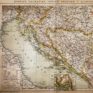
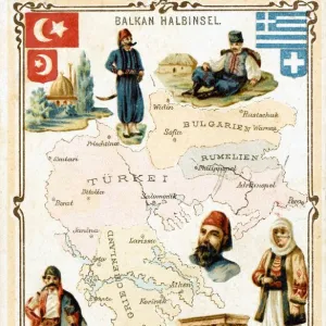
Metal Print : European Turkey map by Th. Duvotenay


![]()
Metal Prints From Mary Evans Picture Library
European Turkey map by Th. Duvotenay
European Turkey map by Thunot Duvotenay. Historia de Turquia by Joseph Marie Jouannin (1783-1844) and Jules Van Gaver, 1840. Date: 2018
Mary Evans Picture Library makes available wonderful images created for people to enjoy over the centuries
Media ID 32246308
© Thaliastock / Mary Evans
1840 Adriatic Albania Balkans Bosnia Bosphorus Bulgaria Cartography Constantinople Domination Mapping Marmara Ottomans Romania Strait Territory Turks Wallachia Ottoman Walachia
16"x20" (51x41cm) Metal Print
Discover the rich history and cultural diversity of Europe and Turkey with our stunning Metal Print of the European Turkey map by Th. Duvotenay. This exquisite map, originally published in 1840 as part of "Historia de Turquia," offers a captivating glimpse into the past. Meticulously reproduced from the Prisma Archivo Fotografico collection at Mary Evans Prints Online, this Metal Print showcases intricate details and vibrant colors, bringing history to life in a contemporary and elegant way. The high-quality metal print material adds a modern and sophisticated touch to any decor, making it a perfect addition to your home or office. Travel back in time and explore the fascinating history of Europe and Turkey with this beautiful and informative piece.
Made with durable metal and luxurious printing techniques, our metal photo prints go beyond traditional canvases, adding a cool, modern touch to your space. Wall mount on back. Eco-friendly 100% post-consumer recycled ChromaLuxe aluminum surface. The thickness of the print is 0.045". Featuring a Scratch-resistant surface and Rounded corners. Backing hangers are attached to the back of the print and float the print 1/2-inch off the wall when hung, the choice of hanger may vary depending on size and International orders will come with Float Mount hangers only. Finished with a brilliant white high gloss surface for unsurpassed detail and vibrance. Printed using Dye-Sublimation and for best care we recommend a non-ammonia glass cleaner, water, or isopropyl (rubbing) alcohol to prevent harming the print surface. We recommend using a clean, lint-free cloth to wipe off the print. The ultra-hard surface is scratch-resistant, waterproof and weatherproof. Avoid direct sunlight exposure.
Made with durable metal and luxurious printing techniques, metal prints bring images to life and add a modern touch to any space
Estimated Image Size (if not cropped) is 50.8cm x 40.6cm (20" x 16")
Estimated Product Size is 51.4cm x 41.2cm (20.2" x 16.2")
These are individually made so all sizes are approximate
Artwork printed orientated as per the preview above, with landscape (horizontal) orientation to match the source image.
FEATURES IN THESE COLLECTIONS
> Mary Evans Prints Online
> New Images July 2023
> Animals
> Mammals
> Cats (Domestic)
> Turkish Van
> Asia
> Turkey
> Related Images
> Europe
> Albania
> Related Images
> Europe
> Bosnia and Herzegovina
> Maps
> Europe
> Bulgaria
> Related Images
EDITORS COMMENTS
This map print, titled "European Turkey" by Th. Duvotenay, is an intriguing glimpse into the political landscape of the European continent during the 19th century. Dated back to 1840, this map was created during the Ottoman Empire's gradual decline, and it illustrates the territorial dominion of the Turks in Europe. The map covers a vast expanse of Europe, stretching from the Adriatic Sea in the west to the Black Sea in the east. The Ottoman territories are depicted in rich, bold tones, highlighting the extent of their influence in the Balkans. The map includes detailed renderings of various regions, such as Albania, Bosnia, Bulgaria, Romania, and Wallachia. One of the most striking features of this map is the clear depiction of the Straits of the Bosphorus and the Dardanelles, which connect Europe and Asia. Constantinople, the historic capital city of the Ottoman Empire, is also prominently displayed. The map's intricate detailing is a testament to the advanced cartography and engraving techniques of the time. This map is an essential historical document, as it provides valuable insights into the geopolitical situation of Europe during the 19th century. It is a reminder of the complex and dynamic nature of European history, as well as the enduring influence of the Ottoman Empire. The map is a beautiful and intriguing piece of historical art, and it continues to fascinate scholars, historians, and enthusiasts of cartography and mapping.
MADE IN THE USA
Safe Shipping with 30 Day Money Back Guarantee
FREE PERSONALISATION*
We are proud to offer a range of customisation features including Personalised Captions, Color Filters and Picture Zoom Tools
SECURE PAYMENTS
We happily accept a wide range of payment options so you can pay for the things you need in the way that is most convenient for you
* Options may vary by product and licensing agreement. Zoomed Pictures can be adjusted in the Basket.