Metal Print > Europe > Poland > Maps
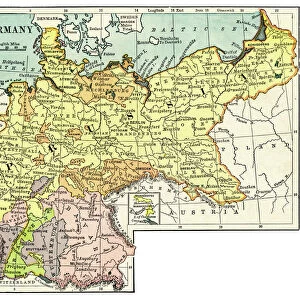
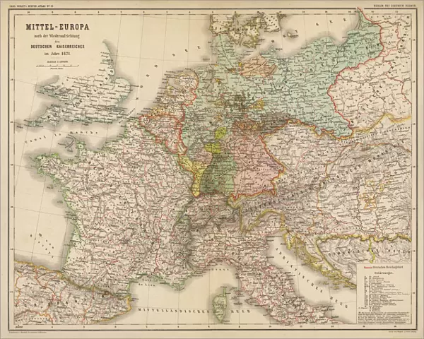
Metal Print : Map / Europe / Germany 1871


![]()
Metal Prints from Mary Evans Picture Library
Map / Europe / Germany 1871
Imperial Germany after the Franco- Prussian War, showing Alsace and Lorraine as part of the country, not to mention huge chunks of Poland in East Prussia
Mary Evans Picture Library makes available wonderful images created for people to enjoy over the centuries
Media ID 594581
© Mary Evans Picture Library 2015 - https://copyrighthub.org/s0/hub1/creation/maryevans/MaryEvansPictureID/10046923
1871 Alsace Franco Huge Lorraine Maps Mention Poland Prussia Prussian Chunks
16"x20" (51x41cm) Metal Print
Step back in time with our stunning Metal Prints from Media Storehouse, featuring this captivating image of Imperial Germany from Mary Evans Picture Library. This evocative map, titled "Map / Europe / Germany 1871," showcases Germany's expansion after the Franco-Prussian War, with Alsace and Lorraine integrated into the country, as well as significant territories in East Prussia. The high-quality metal print brings an unique and modern twist to historical art, with vibrant colors and exceptional detail that will surely make it a conversation starter in your home or office. Order yours today and add a touch of history to your space.
Made with durable metal and luxurious printing techniques, our metal photo prints go beyond traditional canvases, adding a cool, modern touch to your space. Wall mount on back. Eco-friendly 100% post-consumer recycled ChromaLuxe aluminum surface. The thickness of the print is 0.045". Featuring a Scratch-resistant surface and Rounded corners. Backing hangers are attached to the back of the print and float the print 1/2-inch off the wall when hung, the choice of hanger may vary depending on size and International orders will come with Float Mount hangers only. Finished with a brilliant white high gloss surface for unsurpassed detail and vibrance. Printed using Dye-Sublimation and for best care we recommend a non-ammonia glass cleaner, water, or isopropyl (rubbing) alcohol to prevent harming the print surface. We recommend using a clean, lint-free cloth to wipe off the print. The ultra-hard surface is scratch-resistant, waterproof and weatherproof. Avoid direct sunlight exposure.
Made with durable metal and luxurious printing techniques, metal prints bring images to life and add a modern touch to any space
Estimated Image Size (if not cropped) is 50.8cm x 40.6cm (20" x 16")
Estimated Product Size is 51.4cm x 41.2cm (20.2" x 16.2")
These are individually made so all sizes are approximate
Artwork printed orientated as per the preview above, with landscape (horizontal) orientation to match the source image.
FEATURES IN THESE COLLECTIONS
> Mary Evans Prints Online
> Maps
> Europe
> Poland
> Related Images
> Europe
> Related Images
> Maps and Charts
> Early Maps
> Maps and Charts
> Related Images
EDITORS COMMENTS
This historic map print, sourced from Mary Evans Picture Library, offers a captivating glimpse into Imperial Germany in the year 1871, following the Franco-Prussian War. The map meticulously illustrates the significant territorial expansions achieved by Germany during this period, with the annexation of Alsace and Lorraine prominently displayed in the southwest, previously French territories that became German provinces after the war's conclusion. The map also highlights the extensive territorial gains in the east, particularly in the region of East Prussia, where large chunks of present-day Poland are depicted as part of the German Empire. The Prussian provinces of Posen, West Prussia, and Silesia are also clearly marked, reflecting the vast expansion of German influence and control. The map's historical significance lies in its accurate representation of the political landscape of Europe during this pivotal moment in history. The Franco-Prussian War, which lasted from 1870 to 1871, marked the end of the Second French Empire and the rise of the German Empire under the leadership of Otto von Bismarck. This map serves as a visual testament to the profound impact of the war on the European political landscape, reshaping the borders and alliances that would endure for decades to come. The intricate details of this map, from the precise labeling of cities and rivers to the delineation of various territories, offer a fascinating window into the past, inviting viewers to explore the rich history of Europe and the complex web of political relationships that have shaped the continent over the centuries.
MADE IN THE USA
Safe Shipping with 30 Day Money Back Guarantee
FREE PERSONALISATION*
We are proud to offer a range of customisation features including Personalised Captions, Color Filters and Picture Zoom Tools
SECURE PAYMENTS
We happily accept a wide range of payment options so you can pay for the things you need in the way that is most convenient for you
* Options may vary by product and licensing agreement. Zoomed Pictures can be adjusted in the Cart.