Metal Print > Africa > South Africa > Maps
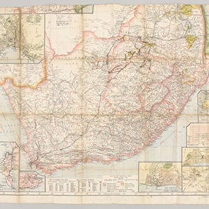
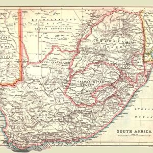
Metal Print : Map /s Africa / Boer C1898


![]()
Metal Prints from Mary Evans Picture Library
Map /s Africa / Boer C1898
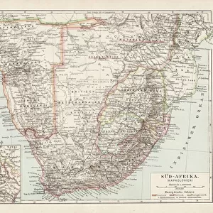
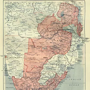
SOUTH AFRICA on the eve of the Boer War
Mary Evans Picture Library makes available wonderful images created for people to enjoy over the centuries
Media ID 571757
© Mary Evans Picture Library 2015 - https://copyrighthub.org/s0/hub1/creation/maryevans/MaryEvansPictureID/10004464
16"x20" (51x41cm) Metal Print
Step back in time with our stunning Metal Print of Map / South Africa / Boer War (C1898) from Mary Evans Picture Library. This captivating image, showcasing South Africa on the eve of the Boer War, is expertly reproduced on a high-quality metal print. The vibrant colors and exceptional detail bring history to life, making it a perfect addition to any home or office decor. The sleek, modern metal surface not only enhances the visual appeal but also ensures durability and longevity. Experience the past in a new light with our exquisite Metal Print from Mary Evans Prints Online.
Made with durable metal and luxurious printing techniques, our metal photo prints go beyond traditional canvases, adding a cool, modern touch to your space. Wall mount on back. Eco-friendly 100% post-consumer recycled ChromaLuxe aluminum surface. The thickness of the print is 0.045". Featuring a Scratch-resistant surface and Rounded corners. Backing hangers are attached to the back of the print and float the print 1/2-inch off the wall when hung, the choice of hanger may vary depending on size and International orders will come with Float Mount hangers only. Finished with a brilliant white high gloss surface for unsurpassed detail and vibrance. Printed using Dye-Sublimation and for best care we recommend a non-ammonia glass cleaner, water, or isopropyl (rubbing) alcohol to prevent harming the print surface. We recommend using a clean, lint-free cloth to wipe off the print. The ultra-hard surface is scratch-resistant, waterproof and weatherproof. Avoid direct sunlight exposure.
Made with durable metal and luxurious printing techniques, metal prints bring images to life and add a modern touch to any space
Estimated Image Size (if not cropped) is 50.8cm x 40.6cm (20" x 16")
Estimated Product Size is 51.4cm x 41.2cm (20.2" x 16.2")
These are individually made so all sizes are approximate
Artwork printed orientated as per the preview above, with landscape (horizontal) orientation to match the source image.
FEATURES IN THESE COLLECTIONS
> Africa
> Related Images
> Africa
> South Africa
> Maps
> Africa
> South Africa
> Related Images
> Maps and Charts
> Early Maps
> Maps and Charts
> Related Images
EDITORS COMMENTS
This historical map print, titled "Map of South Africa, circa 1898: On the Eve of the Boer War," offers a fascinating glimpse into the geopolitical landscape of South Africa just prior to the outbreak of the Second Boer War. The map, from Mary Evans Picture Library, depicts the region with remarkable detail, highlighting the various territories controlled by the British, the Boers, and other European powers. The Boer Wars, a series of conflicts between the British and the Dutch-speaking Boer farmers, began in 1899 and lasted until 1902. This map, produced in 1898, provides a snapshot of the political situation in the region at the height of tensions between the British and the Boers. The map shows the British colonies of the Cape Colony, Natal, and the Transvaal and Orange Free State, which were governed by the Boers. The map also illustrates the various borders and territories claimed by European powers, including Germany and Portugal. The map's intricate detail includes the location of major cities, rivers, mountains, and roads, making it an invaluable resource for scholars and historians studying the period. The map also includes annotations indicating the location of important historical sites, such as the Battle of Majuba Hill, which took place in 1881 and is considered the beginning of the First Boer War. The "Map of South Africa, circa 1898: On the Eve of the Boer War" is a testament to the rich history of South Africa and the complex political situation that led to the conflicts between the British and the Boers. It offers a unique perspective on a pivotal moment in history and is a must-have for any collection focused on African history or the history of colonialism.
MADE IN THE USA
Safe Shipping with 30 Day Money Back Guarantee
FREE PERSONALISATION*
We are proud to offer a range of customisation features including Personalised Captions, Color Filters and Picture Zoom Tools
SECURE PAYMENTS
We happily accept a wide range of payment options so you can pay for the things you need in the way that is most convenient for you
* Options may vary by product and licensing agreement. Zoomed Pictures can be adjusted in the Cart.