Metal Print > Europe > France > Maps
Metal Print : Map / Europe / France 1827


![]()
Metal Prints from Mary Evans Picture Library
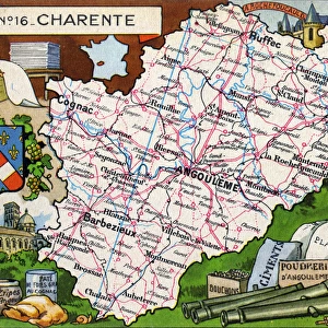
Map / Europe / France 1827
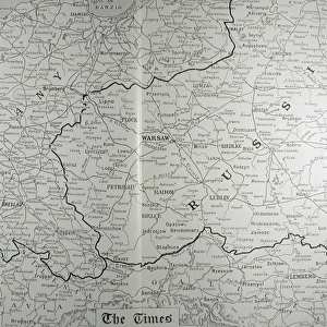
Map of France showing the departements
Mary Evans Picture Library makes available wonderful images created for people to enjoy over the centuries
Media ID 608770
© Mary Evans Picture Library 2015 - https://copyrighthub.org/s0/hub1/creation/maryevans/MaryEvansPictureID/10113867
16"x20" (51x41cm) Metal Print
Discover the timeless beauty of history with our Media Storehouse Metal Prints featuring the captivating Map of France, 1827 from Mary Evans Picture Library at Mary Evans Prints Online. This intricately detailed map showcases the departements of France during that era, making it an excellent addition to any home or office decor. Our high-quality Metal Prints are not just a print, they are a work of art. The vibrant colors and sharp details are brought to life on a durable aluminum sheet, ensuring a long-lasting and stunning display. Elevate your space with this historical and visually appealing Map of France Metal Print from Media Storehouse.
Made with durable metal and luxurious printing techniques, our metal photo prints go beyond traditional canvases, adding a cool, modern touch to your space. Wall mount on back. Eco-friendly 100% post-consumer recycled ChromaLuxe aluminum surface. The thickness of the print is 0.045". Featuring a Scratch-resistant surface and Rounded corners. Backing hangers are attached to the back of the print and float the print 1/2-inch off the wall when hung, the choice of hanger may vary depending on size and International orders will come with Float Mount hangers only. Finished with a brilliant white high gloss surface for unsurpassed detail and vibrance. Printed using Dye-Sublimation and for best care we recommend a non-ammonia glass cleaner, water, or isopropyl (rubbing) alcohol to prevent harming the print surface. We recommend using a clean, lint-free cloth to wipe off the print. The ultra-hard surface is scratch-resistant, waterproof and weatherproof. Avoid direct sunlight exposure.
Made with durable metal and luxurious printing techniques, metal prints bring images to life and add a modern touch to any space
Estimated Image Size (if not cropped) is 50.8cm x 40.6cm (20" x 16")
Estimated Product Size is 51.4cm x 41.2cm (20.2" x 16.2")
These are individually made so all sizes are approximate
Artwork printed orientated as per the preview above, with landscape (horizontal) orientation to match the source image.
FEATURES IN THESE COLLECTIONS
> Europe
> Related Images
> Maps and Charts
> Early Maps
> Maps and Charts
> Related Images
EDITORS COMMENTS
This stunning print of a historical map of France from 1827 offers a fascinating glimpse into the past. The intricate details and borders of each department are clearly defined, showcasing the administrative divisions of the country during this time period. As we study this map, we can see how France was organized and governed nearly two centuries ago.
The vibrant colors and elegant typography used in this map add to its charm, making it not only informative but also visually appealing. Each region is labeled with precision, allowing viewers to easily identify different areas within France.
Looking at this map transports us back in time to an era when cartography was both an art form and a practical tool for understanding geography. It serves as a reminder of the rich history and cultural heritage that France possesses.
Whether you have a personal connection to France or simply appreciate historical maps, this print is sure to capture your imagination. Displaying it in your home or office will not only add a touch of sophistication but also spark conversations about European history and geography. Overall, this print from Mary Evans Picture Library is a timeless piece that celebrates the beauty and complexity of cartography.
MADE IN THE USA
Safe Shipping with 30 Day Money Back Guarantee
FREE PERSONALISATION*
We are proud to offer a range of customisation features including Personalised Captions, Color Filters and Picture Zoom Tools
SECURE PAYMENTS
We happily accept a wide range of payment options so you can pay for the things you need in the way that is most convenient for you
* Options may vary by product and licensing agreement. Zoomed Pictures can be adjusted in the Cart.