Metal Print > Historic > Ancient civilizations > Roman Empire > Roman art
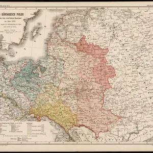
Metal Print : Map of Europe in 1360


![]()
Metal Prints from Mary Evans Picture Library
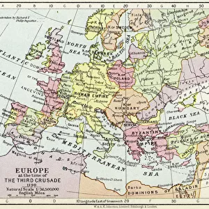
Map of Europe in 1360
A map of Europe in 1360, showing the boundaries of the Holy Roman Empire
Mary Evans Picture Library makes available wonderful images created for people to enjoy over the centuries
Media ID 4344753
© Mary Evans Picture Library 2015 - https://copyrighthub.org/s0/hub1/creation/maryevans/MaryEvansPictureID/10139294
16"x20" (51x41cm) Metal Print
Step back in time with our exquisite Media Storehouse Metal Print of the Map of Europe in 1360, meticulously sourced from Mary Evans Prints Online. This captivating piece of historical cartography showcases the boundaries of the Holy Roman Empire in 1360, offering a unique glimpse into European history. The high-quality metal print brings vibrant colors and intricate details to life, making it a stunning addition to any home or office space. Relive the past with this beautiful and educational display. Order yours today and let history come alive!
Made with durable metal and luxurious printing techniques, our metal photo prints go beyond traditional canvases, adding a cool, modern touch to your space. Wall mount on back. Eco-friendly 100% post-consumer recycled ChromaLuxe aluminum surface. The thickness of the print is 0.045". Featuring a Scratch-resistant surface and Rounded corners. Backing hangers are attached to the back of the print and float the print 1/2-inch off the wall when hung, the choice of hanger may vary depending on size and International orders will come with Float Mount hangers only. Finished with a brilliant white high gloss surface for unsurpassed detail and vibrance. Printed using Dye-Sublimation and for best care we recommend a non-ammonia glass cleaner, water, or isopropyl (rubbing) alcohol to prevent harming the print surface. We recommend using a clean, lint-free cloth to wipe off the print. The ultra-hard surface is scratch-resistant, waterproof and weatherproof. Avoid direct sunlight exposure.
Made with durable metal and luxurious printing techniques, metal prints bring images to life and add a modern touch to any space
Estimated Image Size (if not cropped) is 50.8cm x 40.6cm (20" x 16")
Estimated Product Size is 51.4cm x 41.2cm (20.2" x 16.2")
These are individually made so all sizes are approximate
Artwork printed orientated as per the preview above, with landscape (horizontal) orientation to match the source image.
FEATURES IN THESE COLLECTIONS
> Arts
> Artists
> R
> Roman Roman
> Europe
> Related Images
> Historic
> Ancient civilizations
> Roman Empire
> Roman art
> Maps and Charts
> Early Maps
> Maps and Charts
> Related Images
EDITORS COMMENTS
This print of a map of Europe in 1360 offers a fascinating glimpse into the historical boundaries of the Holy Roman Empire. The intricate details and precise cartography on display showcase the vast expanse of this powerful empire during this pivotal period in European history.
As we study the map, we can see how the Holy Roman Empire extended its influence across much of Central Europe, encompassing modern-day Germany, Austria, Italy, and parts of France. The borders are clearly defined, highlighting the territorial reach and political significance of this medieval superpower.
The inclusion of key cities and regions provides valuable insight into the strategic importance of various locations within the empire. From bustling urban centers to remote rural areas, each place played a crucial role in shaping the economic and cultural landscape of Europe at that time.
By examining this historical map, viewers can gain a deeper appreciation for the complexities and dynamics that shaped medieval Europe. It serves as a reminder of how empires rise and fall, leaving behind legacies that continue to influence our world today.
Overall, this print is not just a visual representation but also an educational tool that invites us to explore and learn more about one of the most significant empires in European history -the Holy Roman Empire.
MADE IN THE USA
Safe Shipping with 30 Day Money Back Guarantee
FREE PERSONALISATION*
We are proud to offer a range of customisation features including Personalised Captions, Color Filters and Picture Zoom Tools
SECURE PAYMENTS
We happily accept a wide range of payment options so you can pay for the things you need in the way that is most convenient for you
* Options may vary by product and licensing agreement. Zoomed Pictures can be adjusted in the Cart.