Metal Print > Arts > Artists > T > John Tallis
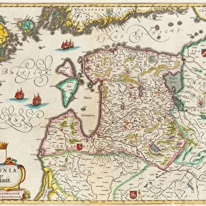
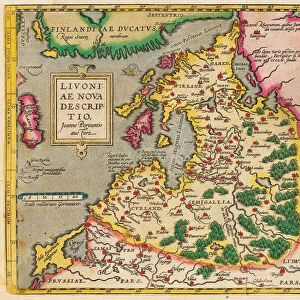
Metal Print : Russia in Europe 1851

![]()
Metal Prints From MapSeeker
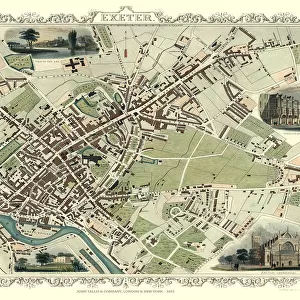
Russia in Europe 1851
A fine facimile artworked from an antique original map of Russia in Europe, issued as part of the 1851 edition of John Tallis and Companys " The Illustrated Atlas and Modern History of the World"
Welcome to the Mapseeker Image library and enter an historic gateway to one of the largest on-line collections of Historic Maps, Nostalgic Views, Vista's and Panorama's from a World gone by.
Media ID 20347523
© Mapseeker Publishing Ltd
John Tallis John Tallis Map Tallis Map
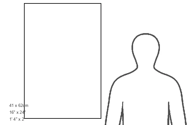
16"x24" (61x41cm) Metal Print
Experience the historical charm of Russia in Europe as depicted in this stunning Metal Print from Media Storehouse. This exquisite reproduction is taken from the 1851 edition of John Tallis and Company's "The Illustrated Atlas," created by John Tallis and John Rapkin of MapSeeker. The intricate details of this antique map of Russia in Europe, 1851, are brought to life in vibrant colors and sharp clarity on a durable metal print. Add a touch of history and elegance to your home or office decor with this beautiful and unique piece of art.
Made with durable metal and luxurious printing techniques, our metal photo prints go beyond traditional canvases, adding a cool, modern touch to your space. Wall mount on back. Eco-friendly 100% post-consumer recycled ChromaLuxe aluminum surface. The thickness of the print is 0.045". Featuring a Scratch-resistant surface and Rounded corners. Backing hangers are attached to the back of the print and float the print 1/2-inch off the wall when hung, the choice of hanger may vary depending on size and International orders will come with Float Mount hangers only. Finished with a brilliant white high gloss surface for unsurpassed detail and vibrance. Printed using Dye-Sublimation and for best care we recommend a non-ammonia glass cleaner, water, or isopropyl (rubbing) alcohol to prevent harming the print surface. We recommend using a clean, lint-free cloth to wipe off the print. The ultra-hard surface is scratch-resistant, waterproof and weatherproof. Avoid direct sunlight exposure.
Made with durable metal and luxurious printing techniques, metal prints bring images to life and add a modern touch to any space
Estimated Product Size is 41.2cm x 61.5cm (16.2" x 24.2")
These are individually made so all sizes are approximate
Artwork printed orientated as per the preview above, with portrait (vertical) orientation to match the source image.
FEATURES IN THESE COLLECTIONS
> Arts
> Artists
> T
> John Tallis
> Maps and Charts
> World
EDITORS COMMENTS
This print showcases a remarkable piece of cartographic history - a fine facsimile artworked from an antique original map of Russia in Europe, dating back to 1851. This exquisite map was originally issued as part of the renowned 1851 edition of John Tallis and Company's "The Illustrated Atlas and Modern History of the World". With its intricate details and elegant design, this old map offers a fascinating glimpse into the past, allowing us to explore the vast expanse of Russia in Europe during that era. From Moscow to St. Petersburg, from the Baltic Sea to the Black Sea, every city, river, and mountain range is meticulously depicted on this historical gem. Created by esteemed cartographers John Tallis and John Rapkin, this masterpiece reflects their dedication to accuracy and artistry. The delicate lines and vibrant colors bring life to each region while evoking a sense of nostalgia for a bygone era. As we gaze upon this image, we are transported back in time - imagining horse-drawn carriages traversing ancient roads or sailors navigating through uncharted waters. It serves as a testament to human curiosity and our relentless pursuit of knowledge about our world. Whether you are an avid historian or simply appreciate beautiful works of art, this print is sure to captivate your imagination with its rich history and timeless beauty.
MADE IN THE USA
Safe Shipping with 30 Day Money Back Guarantee
FREE PERSONALISATION*
We are proud to offer a range of customisation features including Personalised Captions, Color Filters and Picture Zoom Tools
SECURE PAYMENTS
We happily accept a wide range of payment options so you can pay for the things you need in the way that is most convenient for you
* Options may vary by product and licensing agreement. Zoomed Pictures can be adjusted in the Basket.