Metal Print > Europe > United Kingdom > Scotland > Clackmannanshire > Clackmannan
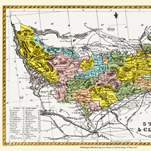
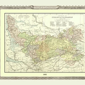
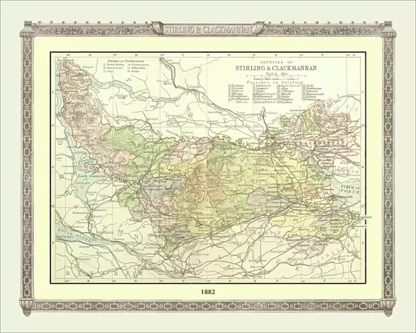
Metal Print : Old Map of the Counties of Stirling and Clackmannan from the Philips Handy Atlas of 1882


![]()
Metal Prints from MapSeeker
Old Map of the Counties of Stirling and Clackmannan from the Philips Handy Atlas of 1882
PHA029
Welcome to the Mapseeker Image library and enter an historic gateway to one of the largest on-line collections of Historic Maps, Nostalgic Views, Vista's and Panorama's from a World gone by.
Media ID 20348201
County Map County Map Of Scotland Historic Map Old County Map Old Scottish County Map Scottish County Map Clackmannan Clackmannanshire Stirling Stirlingshire
16"x20" (51x41cm) Metal Print
Step back in time with our stunning Metal Print of an Old Map of Stirling and Clackmannan Counties from the Philips Handy Atlas of 1882, exclusively available at Media Storehouse from MapSeeker. This beautiful metal print features intricate details and vibrant colors, bringing the historical cartography of the past to life. The sturdy metal material ensures a long-lasting and durable addition to your home or office decor. Relive the rich history of Scotland with this unique and captivating piece.
Made with durable metal and luxurious printing techniques, our metal photo prints go beyond traditional canvases, adding a cool, modern touch to your space. Wall mount on back. Eco-friendly 100% post-consumer recycled ChromaLuxe aluminum surface. The thickness of the print is 0.045". Featuring a Scratch-resistant surface and Rounded corners. Backing hangers are attached to the back of the print and float the print 1/2-inch off the wall when hung, the choice of hanger may vary depending on size and International orders will come with Float Mount hangers only. Finished with a brilliant white high gloss surface for unsurpassed detail and vibrance. Printed using Dye-Sublimation and for best care we recommend a non-ammonia glass cleaner, water, or isopropyl (rubbing) alcohol to prevent harming the print surface. We recommend using a clean, lint-free cloth to wipe off the print. The ultra-hard surface is scratch-resistant, waterproof and weatherproof. Avoid direct sunlight exposure.
Made with durable metal and luxurious printing techniques, metal prints bring images to life and add a modern touch to any space
Estimated Image Size (if not cropped) is 50.8cm x 40.6cm (20" x 16")
Estimated Product Size is 51.4cm x 41.2cm (20.2" x 16.2")
These are individually made so all sizes are approximate
Artwork printed orientated as per the preview above, with landscape (horizontal) orientation to match the source image.
FEATURES IN THESE COLLECTIONS
> MapSeeker
> Maps from the British Isles
> Scotland and Counties PORTFOLIO
> Europe
> United Kingdom
> Scotland
> Clackmannanshire
> Clackmannan
> Europe
> United Kingdom
> Scotland
> Clackmannanshire
> Related Images
> Europe
> United Kingdom
> Scotland
> Maps
> Europe
> United Kingdom
> Scotland
> Posters
> Europe
> United Kingdom
> Scotland
> Related Images
> Europe
> United Kingdom
> Scotland
> Stirling
> Europe
> United Kingdom
> Scotland
> Stirlingshire
> Related Images
> Europe
> United Kingdom
> Scotland
> Stirlingshire
> Stirling
> Maps and Charts
> Early Maps
> Maps and Charts
> Related Images
EDITORS COMMENTS
This print showcases an exquisite piece of history - the Old Map of the Counties of Stirling and Clackmannan from the Philips Handy Atlas of 1882 (PHA029). Steeped in Scottish heritage, this vintage county map offers a fascinating glimpse into the past. With intricate details and delicate craftsmanship, this old Scottish county map takes us on a journey through time. It reveals the boundaries and topography of Stirling and Clackmannan counties, providing a window into their rich historical significance. The map's aged appearance adds to its charm, evoking nostalgia for bygone eras. Stirlingshire, with its iconic city of Stirling at its heart, is beautifully depicted on this historic map. From rolling hills to winding rivers, every contour is meticulously illustrated. Meanwhile, Clackmannanshire's unique character shines through as it nestles between Fife and Perthshire. As we explore this remarkable piece of cartographic artistry, we are transported back to a time when these counties were bustling centers of activity. This visual treasure not only serves as a testament to Scotland's enduring legacy but also invites us to reflect upon our own place within history. Whether you have ancestral ties or simply appreciate the beauty of antique maps, this print captures the essence of Stirling and Clackmannan like no other. Display it proudly in your home or office space as a conversation starter that celebrates both local heritage and timeless craftsmanship.
MADE IN THE USA
Safe Shipping with 30 Day Money Back Guarantee
FREE PERSONALISATION*
We are proud to offer a range of customisation features including Personalised Captions, Color Filters and Picture Zoom Tools
SECURE PAYMENTS
We happily accept a wide range of payment options so you can pay for the things you need in the way that is most convenient for you
* Options may vary by product and licensing agreement. Zoomed Pictures can be adjusted in the Cart.