Metal Print > Europe > United Kingdom > England > London > Towns > Welling
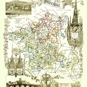
Metal Print : Old County Map of Warwickshire 1836 by Thomas Moule


![]()
Metal Prints from MapSeeker
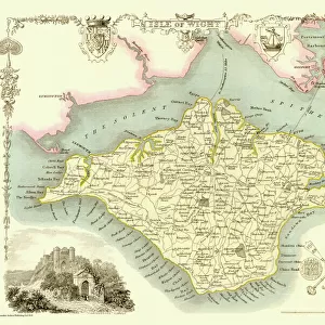
Old County Map of Warwickshire 1836 by Thomas Moule
This is a fine decorative reproduction County Map of Warwickshire from the First Edition series of Thomas Moule Maps, originally Published in 1836. The well-known series of County Maps which are known as Moules feature beautiful vignette views and were first published in separate sections for each county in 1830-32, they were then published in collected form in a two-volume work: The English Counties Delineated: or a Topographical Description of England: Illustrated by a Complete Series of County Maps by Thomas Moule: London: Published by George Virtue 1836
Welcome to the Mapseeker Image library and enter an historic gateway to one of the largest on-line collections of Historic Maps, Nostalgic Views, Vista's and Panorama's from a World gone by.
Media ID 20347919
© Mapseeker Publishing Ltd
County Map County Map Of England English County Map Historic Map Moule Map Old County Map Old English County Map Old Moule Map Thomas Moule Thomas Moule Map Warwickshire
16"x20" (51x41cm) Metal Print
Step back in time with our exquisite Metal Print of the Old County Map of Warwickshire 1836 by Thomas Moule. This intricately detailed reproduction, sourced from the First Edition series of Thomas Moule Maps, originally published in 1836, is a must-have for history enthusiasts and decorators alike. The vintage map, created by Thomas Moule and George Virtue from MapSeeker, is beautifully rendered on a durable metal print, adding a unique and timeless touch to any room. Bring the history of Warwickshire into your home with this stunning and decorative piece.
Made with durable metal and luxurious printing techniques, our metal photo prints go beyond traditional canvases, adding a cool, modern touch to your space. Wall mount on back. Eco-friendly 100% post-consumer recycled ChromaLuxe aluminum surface. The thickness of the print is 0.045". Featuring a Scratch-resistant surface and Rounded corners. Backing hangers are attached to the back of the print and float the print 1/2-inch off the wall when hung, the choice of hanger may vary depending on size and International orders will come with Float Mount hangers only. Finished with a brilliant white high gloss surface for unsurpassed detail and vibrance. Printed using Dye-Sublimation and for best care we recommend a non-ammonia glass cleaner, water, or isopropyl (rubbing) alcohol to prevent harming the print surface. We recommend using a clean, lint-free cloth to wipe off the print. The ultra-hard surface is scratch-resistant, waterproof and weatherproof. Avoid direct sunlight exposure.
Made with durable metal and luxurious printing techniques, metal prints bring images to life and add a modern touch to any space
Estimated Image Size (if not cropped) is 40.6cm x 50.8cm (16" x 20")
Estimated Product Size is 41.2cm x 51.4cm (16.2" x 20.2")
These are individually made so all sizes are approximate
Artwork printed orientated as per the preview above, with portrait (vertical) orientation to match the source image.
FEATURES IN THESE COLLECTIONS
> MapSeeker
> Maps from the British Isles
> England and Counties PORTFOLIO
> Arts
> Artists
> M
> Thomas Moule
> Europe
> United Kingdom
> England
> London
> Towns
> Welling
> Europe
> United Kingdom
> England
> Maps
> Europe
> United Kingdom
> England
> Warwickshire
> Related Images
> Europe
> United Kingdom
> England
> Wells
> Maps and Charts
> Early Maps
> Maps and Charts
> Related Images
EDITORS COMMENTS
This exquisite print showcases the "Old County Map of Warwickshire 1836" by Thomas Moule, a renowned cartographer of his time. Originally published in 1836 as part of Moule's First Edition series, this decorative reproduction offers a glimpse into the rich history and topography of Warwickshire. Moule's County Maps are widely celebrated for their intricate details and captivating vignette views. Each county was meticulously depicted in separate sections between 1830-32 before being compiled into a two-volume masterpiece titled "The English Counties Delineated: or a Topographical Description of England". Published by George Virtue in London, this comprehensive collection became an invaluable resource for those seeking to explore and understand the diverse landscapes across England. Warwickshire, known for its picturesque countryside and historic landmarks, is beautifully represented on this map. From charming villages to grand castles, every corner is brought to life with Moule's artistic flair. This historical gem not only serves as a testament to the craftsmanship of both Thomas Moule and George Virtue but also provides an opportunity to delve into the past and appreciate the evolution of Warwickshire over time. Whether you are an avid historian or simply captivated by old maps, this print invites you to immerse yourself in the enchanting world captured by Thomas Moule. Display it proudly on your wall and let it transport you back to an era where exploration was at its peak and cartography was considered an art form.
MADE IN THE USA
Safe Shipping with 30 Day Money Back Guarantee
FREE PERSONALISATION*
We are proud to offer a range of customisation features including Personalised Captions, Color Filters and Picture Zoom Tools
SECURE PAYMENTS
We happily accept a wide range of payment options so you can pay for the things you need in the way that is most convenient for you
* Options may vary by product and licensing agreement. Zoomed Pictures can be adjusted in the Cart.