Metal Print > Arts > Artists > S > John Speed
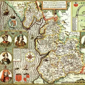
Metal Print : Old County Map of Leicestershire 1611 by John Speed


Metal Prints From MapSeeker
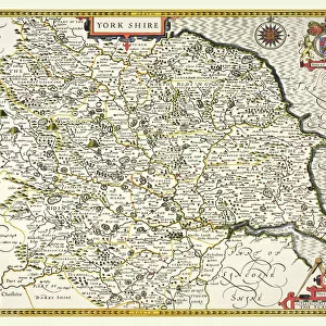
Old County Map of Leicestershire 1611 by John Speed
A facimile of John Speeds historical map of Leicestershire originally published for the " Theatre of the Empire of Great Britain", an atlas to accompany " a history of Great Britain"
Welcome to the Mapseeker Image library and enter an historic gateway to one of the largest on-line collections of Historic Maps, Nostalgic Views, Vista's and Panorama's from a World gone by.
Media ID 20347556
© Mapseeker Publishing Ltd
County Map County Map Of England English County Map Historic Map John Speed Map Old County Map Old English County Map Speed Map Speede Map Leicestershire
16"x24" (61x41cm) Metal Print
Step back in time with our exquisite Metal Print of the Old County Map of Leicestershire, 1611 by John Speed from MapSeeker. This beautiful reproduction of the historical map, originally published for the "Theatre of the Empire of Great Britain," is now available as a stylish and durable Metal Print from Media Storehouse. John Speed's intricate cartography showcases the details of Leicestershire in the early 17th century, making this print an exceptional addition to any home or office. The vibrant colors and high-quality finish of the Metal Print bring out the intricacies of the map, ensuring that this piece is not just a decorative item, but a conversation starter and a window into history. Order yours today and let the rich history of Leicestershire come alive in your space.
Made with durable metal and luxurious printing techniques, our metal photo prints go beyond traditional canvases, adding a cool, modern touch to your space. Wall mount on back. Eco-friendly 100% post-consumer recycled ChromaLuxe aluminum surface. The thickness of the print is 0.045". Featuring a Scratch-resistant surface and Rounded corners. Backing hangers are attached to the back of the print and float the print 1/2-inch off the wall when hung, the choice of hanger may vary depending on size and International orders will come with Float Mount hangers only. Finished with a brilliant white high gloss surface for unsurpassed detail and vibrance. Printed using Dye-Sublimation and for best care we recommend a non-ammonia glass cleaner, water, or isopropyl (rubbing) alcohol to prevent harming the print surface. We recommend using a clean, lint-free cloth to wipe off the print. The ultra-hard surface is scratch-resistant, waterproof and weatherproof. Avoid direct sunlight exposure.
Made with durable metal and luxurious printing techniques, metal prints bring images to life and add a modern touch to any space
Estimated Product Size is 61.5cm x 41.2cm (24.2" x 16.2")
These are individually made so all sizes are approximate
Artwork printed orientated as per the preview above, with landscape (horizontal) orientation to match the source image.
FEATURES IN THESE COLLECTIONS
> Arts
> Artists
> S
> John Speed
> Europe
> United Kingdom
> England
> Leicestershire
> Related Images
> Europe
> United Kingdom
> England
> Maps
> Maps and Charts
> British Empire Maps
> Maps and Charts
> Early Maps
EDITORS COMMENTS
This print showcases the "Old County Map of Leicestershire 1611" by the renowned cartographer John Speed. A remarkable facsimile of his original work published for the esteemed "Theatre of the Empire of Great Britain" this map is an invaluable piece of history accompanying a comprehensive account of Great Britain's past. With its intricate details and exquisite craftsmanship, this English county map transports us back in time to the early 17th century. Every line and curve on this old county map tells a story, revealing Leicestershire's rich heritage and geographical features that have shaped its identity over centuries. John Speed's expertise shines through as he meticulously captures every town, village, river, and road within Leicestershire. This historic map serves as a window into a bygone era when exploration was at its peak and cartography was both an art form and scientific endeavor. As we delve into this fascinating historical artifact, we are reminded of how maps like these were once essential tools for navigation, governance, and understanding our world. The attention to detail in John Speed's work is awe-inspiring; it not only provides valuable insights into Leicestershire's past but also stands as a testament to human curiosity about our surroundings. Whether you are an avid historian or simply appreciate fine artistry, this old county map offers a glimpse into England's vibrant past while honoring John Speed's enduring legacy as one of history's most celebrated cartographers.
MADE IN THE USA
Safe Shipping with 30 Day Money Back Guarantee
FREE PERSONALISATION*
We are proud to offer a range of customisation features including Personalised Captions, Color Filters and Picture Zoom Tools
SECURE PAYMENTS
We happily accept a wide range of payment options so you can pay for the things you need in the way that is most convenient for you
* Options may vary by product and licensing agreement. Zoomed Pictures can be adjusted in the Basket.