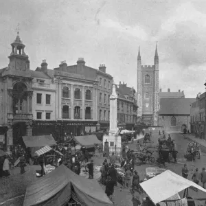
Metal Print > Europe > United Kingdom > England > Buckinghamshire > Buckingham
Metal Print : Old County Map of Buckinghamshire 1611 by John Speed


Metal Prints from MapSeeker
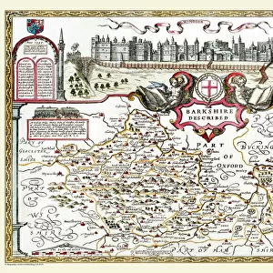
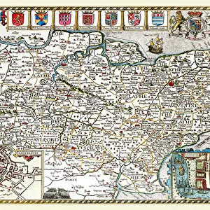
Old County Map of Buckinghamshire 1611 by John Speed
A fine reproduction of John Speeds historical map of Buckinghamshire originally published for the " Theatre of the Empire of Great Britain", an atlas to accompany " a history of Great Britain".
At the top corner are town plans of Buckingham and, curiously, Reading. Speed has added a note, explaining that as there was not room for the Reading plan on his map of Berkshire, as it is " one of the most ancient and chiefest" towns in the county, he has added it to the Bucks one. On the bottom corners of the map are engraved arches, containing the coats of arms of the " honourable families" of the area and the Royal Arms. The boundaries of the hundreds, large estates, towns, some villages, hills and rivers and shown. The River Thames forms the southern boundary of the county
Welcome to the Mapseeker Image library and enter an historic gateway to one of the largest on-line collections of Historic Maps, Nostalgic Views, Vista's and Panorama's from a World gone by.
Media ID 20347763
© Mapseeker Publishing Ltd
County Map County Map Of England English County Map Historic Map John Speed Map Old County Map Old English County Map Speed Map Speede Map Buckinghamshire
16"x24" (61x41cm) Metal Print
Step back in time with our exquisite Metal Print of the Old County Map of Buckinghamshire, originally published by renowned cartographer John Speed in 1611. This intricately detailed reproduction, sourced from MapSeeker, showcases the historical beauty of Buckinghamshire as it once was. The vintage map is meticulously transferred onto a high-quality metal sheet, giving it a distinctive and elegant look. Each print is coated with a protective layer to preserve its vibrant colors and sharp details. Hang this captivating piece in your home or office to add a touch of history and character to your space.
Made with durable metal and luxurious printing techniques, our metal photo prints go beyond traditional canvases, adding a cool, modern touch to your space. Wall mount on back. Eco-friendly 100% post-consumer recycled ChromaLuxe aluminum surface. The thickness of the print is 0.045". Featuring a Scratch-resistant surface and Rounded corners. Backing hangers are attached to the back of the print and float the print 1/2-inch off the wall when hung, the choice of hanger may vary depending on size and International orders will come with Float Mount hangers only. Finished with a brilliant white high gloss surface for unsurpassed detail and vibrance. Printed using Dye-Sublimation and for best care we recommend a non-ammonia glass cleaner, water, or isopropyl (rubbing) alcohol to prevent harming the print surface. We recommend using a clean, lint-free cloth to wipe off the print. The ultra-hard surface is scratch-resistant, waterproof and weatherproof. Avoid direct sunlight exposure.
Made with durable metal and luxurious printing techniques, metal prints bring images to life and add a modern touch to any space
Estimated Product Size is 61.5cm x 41.2cm (24.2" x 16.2")
These are individually made so all sizes are approximate
Artwork printed orientated as per the preview above, with landscape (horizontal) orientation to match the source image.
FEATURES IN THESE COLLECTIONS
> MapSeeker
> Maps from the British Isles
> England and Counties PORTFOLIO
> Arts
> Artists
> H
> John Hillers
> Arts
> Artists
> H
> John Hills
> Arts
> Artists
> S
> John Speed
> Europe
> United Kingdom
> England
> Berkshire
> Reading
> Europe
> United Kingdom
> England
> Berkshire
> Related Images
> Europe
> United Kingdom
> England
> Berkshire
> Thames
> Europe
> United Kingdom
> England
> Buckinghamshire
> Buckingham
> Europe
> United Kingdom
> England
> Buckinghamshire
> Related Images
> Europe
> United Kingdom
> England
> London
> River Thames
> Europe
> United Kingdom
> England
> Maps
EDITORS COMMENTS
This stunning print showcases the "Old County Map of Buckinghamshire 1611" by John Speed, a renowned cartographer of his time. Originally published for the "Theatre of the Empire of Great Britain" an atlas accompanying a comprehensive history of Great Britain, this reproduction captures the intricate details and historical significance of Speed's map. At first glance, one is drawn to the top corners where town plans of Buckingham and Reading are unexpectedly juxtaposed. Speed himself explains that due to limited space on his map of Berkshire, he included Reading in his depiction of Buckinghamshire as it holds great importance as one of the oldest and most prominent towns in its respective county. The bottom corners feature beautifully engraved arches adorned with coats-of-arms representing honorable families from the area, along with the Royal Arms. These symbols serve as a testament to both local pride and royal authority during that era. Speed's meticulous attention to detail is evident throughout this map. The boundaries demarcating hundreds (administrative divisions), large estates, towns, villages, hills, and rivers are all meticulously depicted. Notably, the River Thames forms a natural southern boundary for Buckinghamshire. This historic map offers viewers a glimpse into 17th-century England while providing valuable insights into local geography and societal structures at that time. A true treasure for history enthusiasts or anyone seeking to explore Buckinghamshire's rich heritage through cartography.
MADE IN THE USA
Safe Shipping with 30 Day Money Back Guarantee
FREE PERSONALISATION*
We are proud to offer a range of customisation features including Personalised Captions, Color Filters and Picture Zoom Tools
SECURE PAYMENTS
We happily accept a wide range of payment options so you can pay for the things you need in the way that is most convenient for you
* Options may vary by product and licensing agreement. Zoomed Pictures can be adjusted in the Cart.