Metal Print > Arts > Artists > H > Jodocus Hondius
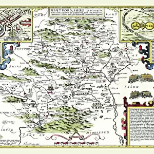
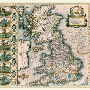
Metal Print : Old Map of The British Isles 1635 by Willem & Johan Blaeu from the Theatrum Orbis Terrarum


![]()
Metal Prints from MapSeeker
Old Map of The British Isles 1635 by Willem & Johan Blaeu from the Theatrum Orbis Terrarum
This detailed and most attractive reproduction map of The British Isles has been carefully art worked from a scan of an antique original. The famous firm of Dutch cartographers and publishers was established in the late 16th century by Willem Janszoon Blaeu in Amsterdam. Blaeu was a maker of globes and scientific instruments and purchased some of his early map plates from Jodocus Hondius. From this small beginning was to emerge one of the largest and most prolific map publishing houses of the seventeenth century
Welcome to the Mapseeker Image library and enter an historic gateway to one of the largest on-line collections of Historic Maps, Nostalgic Views, Vista's and Panorama's from a World gone by.
Media ID 20348005
Blaeu Blaeu Family Blaue Map Historic Map Johan Blaeu Johan Blaeu Map Old Blaue Map British Isles
16"x24" (61x41cm) Metal Print
Step back in time with our exquisite Metal Print of the Old Map of The British Isles, crafted from the 1635 edition by Willem & Johan Blaeu from Theatrum Orbis Terrarum. This intricately detailed reproduction, sourced from MapSeeker, showcases the rich historical cartography of an era long past. Each Metal Print is meticulously art worked from a high-resolution scan of the original antique map, ensuring the finest details are preserved. Elevate your home or office decor with this captivating piece of history, a true conversation starter and a reminder of the intriguing stories that lie within the lines of this magnificent map.
Made with durable metal and luxurious printing techniques, our metal photo prints go beyond traditional canvases, adding a cool, modern touch to your space. Wall mount on back. Eco-friendly 100% post-consumer recycled ChromaLuxe aluminum surface. The thickness of the print is 0.045". Featuring a Scratch-resistant surface and Rounded corners. Backing hangers are attached to the back of the print and float the print 1/2-inch off the wall when hung, the choice of hanger may vary depending on size and International orders will come with Float Mount hangers only. Finished with a brilliant white high gloss surface for unsurpassed detail and vibrance. Printed using Dye-Sublimation and for best care we recommend a non-ammonia glass cleaner, water, or isopropyl (rubbing) alcohol to prevent harming the print surface. We recommend using a clean, lint-free cloth to wipe off the print. The ultra-hard surface is scratch-resistant, waterproof and weatherproof. Avoid direct sunlight exposure.
Made with durable metal and luxurious printing techniques, metal prints bring images to life and add a modern touch to any space
Estimated Product Size is 61.5cm x 41.2cm (24.2" x 16.2")
These are individually made so all sizes are approximate
Artwork printed orientated as per the preview above, with landscape (horizontal) orientation to match the source image.
FEATURES IN THESE COLLECTIONS
> MapSeeker
> Maps from the British Isles
> British Isles Map PORTFOLIO
> Arts
> Artists
> B
> Willem Blaeu
> Arts
> Artists
> H
> Jodocus Hondius
> Arts
> Photorealistic artworks
> Detailed art pieces
> Masterful detailing in art
> Maps and Charts
> Early Maps
> Maps and Charts
> Willem Janszoon Blaeu
EDITORS COMMENTS
This beautifully crafted reproduction of the "Old Map of The British Isles 1635" by Willem & Johan Blaeu takes us back in time to the rich history and intricate cartography of the seventeenth century. Carefully art worked from a scan of an antique original, this detailed map showcases the expertise and craftsmanship that made the Blaeu family one of the most renowned cartographers and publishers of their time. Established by Willem Janszoon Blaeu in Amsterdam, this Dutch firm initially specialized in globe-making and scientific instruments before venturing into map publishing. Acquiring some map plates from Jodocus Hondius, they laid the foundation for what would become a prolific map publishing house during the seventeenth century. The historic significance of this particular map lies in its depiction of The British Isles, offering a glimpse into how these lands were perceived over three centuries ago. With intricate details capturing coastlines, cities, rivers, and topographical features, it provides valuable insights into both geographical knowledge and artistic representation at that time. Whether you are a history enthusiast or simply appreciate fine craftsmanship, this reproduction allows you to admire an old-world treasure right at your fingertips. Let yourself be transported to an era where maps were not only practical tools but also works of art that ignited curiosity about distant lands.
MADE IN THE USA
Safe Shipping with 30 Day Money Back Guarantee
FREE PERSONALISATION*
We are proud to offer a range of customisation features including Personalised Captions, Color Filters and Picture Zoom Tools
SECURE PAYMENTS
We happily accept a wide range of payment options so you can pay for the things you need in the way that is most convenient for you
* Options may vary by product and licensing agreement. Zoomed Pictures can be adjusted in the Cart.