Metal Print > Arts > Photorealistic artworks > Detailed art pieces > Masterful detailing in art
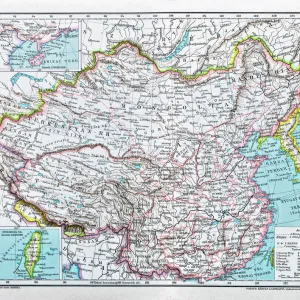
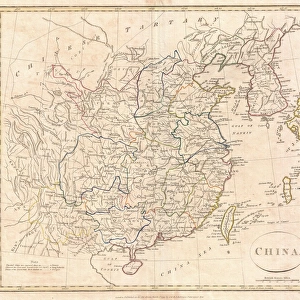
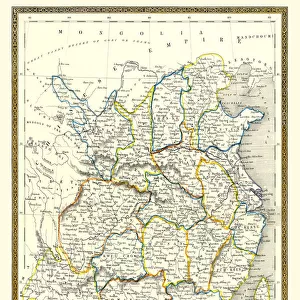
Metal Print : Old Map of China 1852 by Henry George Collins

![]()
Metal Prints From MapSeeker
Old Map of China 1852 by Henry George Collins
This is a finely detailed map of China remastered from a rare Atlas of the World published in 1852 by Henry George Collins. Although these Henry Collins produced maps of the highest quality in his time unfortunately not the same could be said in terms of his business success. His maps were later obtained by the famous Stanford Map Company and used in their publications
Welcome to the Mapseeker Image library and enter an historic gateway to one of the largest on-line collections of Historic Maps, Nostalgic Views, Vista's and Panorama's from a World gone by.
Media ID 20347233
© Mapseeker Publishing Ltd
Collins Collins Atlas Collins Atlas Map Collins Map
16"x24" (61x41cm) Metal Print
Step back in time with our exquisite Metal Print of the Old Map of China, originally created by Henry George Collins in 1852. Meticulously remastered from the rare Atlas of the World published by MapSeeker, this finely detailed map transports you to a bygone era. The vibrant colors and sharp lines pop against the sleek, modern metal surface, making it a stunning addition to any room. Bring history into your home with this unique and captivating piece of art.
Made with durable metal and luxurious printing techniques, our metal photo prints go beyond traditional canvases, adding a cool, modern touch to your space. Wall mount on back. Eco-friendly 100% post-consumer recycled ChromaLuxe aluminum surface. The thickness of the print is 0.045". Featuring a Scratch-resistant surface and Rounded corners. Backing hangers are attached to the back of the print and float the print 1/2-inch off the wall when hung, the choice of hanger may vary depending on size and International orders will come with Float Mount hangers only. Finished with a brilliant white high gloss surface for unsurpassed detail and vibrance. Printed using Dye-Sublimation and for best care we recommend a non-ammonia glass cleaner, water, or isopropyl (rubbing) alcohol to prevent harming the print surface. We recommend using a clean, lint-free cloth to wipe off the print. The ultra-hard surface is scratch-resistant, waterproof and weatherproof. Avoid direct sunlight exposure.
Made with durable metal and luxurious printing techniques, metal prints bring images to life and add a modern touch to any space
Estimated Product Size is 41.2cm x 61.5cm (16.2" x 24.2")
These are individually made so all sizes are approximate
Artwork printed orientated as per the preview above, with portrait (vertical) orientation to match the source image.
FEATURES IN THESE COLLECTIONS
> MapSeeker
> Maps of Asia and Middle East
> Maps of Countries in Asia PORTFOLIO
> Arts
> Photorealistic artworks
> Detailed art pieces
> Masterful detailing in art
> Maps and Charts
> World
EDITORS COMMENTS
This beautifully restored print showcases an exquisite piece of cartographic history - the "Old Map of China 1852" by Henry George Collins. Created with meticulous attention to detail, this map is a testament to Collins' exceptional craftsmanship during his time. Unfortunately, despite his undeniable talent, Collins did not achieve the same level of success in business. However, fate had other plans for these remarkable maps. The renowned Stanford Map Company recognized their value and acquired them for use in their own publications. This collaboration ensured that Collins' work would continue to be appreciated and shared with future generations. The "Old Map of China 1852" offers a captivating glimpse into the past, revealing the intricate geography and rich cultural heritage of China during that era. From its vibrant cities to its sprawling landscapes, every corner is meticulously depicted on this historic artifact. Whether you are an avid collector or simply fascinated by Chinese history, this print will transport you back in time and allow you to explore the wonders of old China from the comfort of your own home. Display it proudly as a conversation starter or use it as a valuable resource for research and study. Henry George Collins may not have achieved commercial success during his lifetime, but his legacy lives on through this extraordinary map - now available for all those who appreciate fine cartography and cherish our world's diverse history.
MADE IN THE USA
Safe Shipping with 30 Day Money Back Guarantee
FREE PERSONALISATION*
We are proud to offer a range of customisation features including Personalised Captions, Color Filters and Picture Zoom Tools
SECURE PAYMENTS
We happily accept a wide range of payment options so you can pay for the things you need in the way that is most convenient for you
* Options may vary by product and licensing agreement. Zoomed Pictures can be adjusted in the Basket.